Waischenfeld
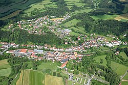
Waischenfeld is a town in the district of Bayreuth, in Bavaria, Germany. It is in Franconian Switzerland, 20 km southwest of Bayreuth.
 | |
| Coordinates: 49°51′N 11°20′E / 49.850°N 11.333°ECoordinates: 49°51′N 11°20′E / 49.850°N 11.333°E | |
| Country | Germany |
| State | Bavaria |
| Admin. region | Oberfranken |
| District | Bayreuth |
| Government | |
| • Mayor (2020–26) | Thomas Thiem[1] (CSU) |
| Area | |
| • Total | 55.65 km2 (21.49 sq mi) |
| Elevation | 372 m (1,220 ft) |
| Population (2016-12-31)[2] | |
| • Total | 3,069 |
| • Density | 55.148/km2 (142.83/sq mi) |
| Time zone | UTC+01:00 (CET) |
| • Summer (DST) | UTC+02:00 (CEST) |
| Postal codes | 91344 |
| Vehicle registration | BT |
| Website | www.waischenfeld.de |
It consists of the following districts: Aalkorb, Breitenlesau, Doos, Eichenbirkig, Gösseldorf, Gutenbiegen, Hammermühle, Hannberg, Heroldsberg, Heroldsberg-Tal, Hubenberg, Köttweinsdorf, Kugelau, Langenloh, Löhlitz, Nankendorf, Neusig, Pulvermühle, Rabeneck, Sauerhof, Saugendorf, Schafhof, Schlößlein, Schönhaid, Schönhof, Seelig, Siegritzberg, Waischenfeld, Zeubach.[3]
The town is the place of Waischenfeld Castle.
References
- ↑ Liste der ersten Bürgermeister/Oberbürgermeister in kreisangehörigen Gemeinden, Bayerisches Landesamt für Statistik, 15 July 2021.
- ↑ "Fortschreibung des Bevölkerungsstandes". Bayerisches Landesamt für Statistik und Datenverarbeitung (in German). January 2018.
{{cite web}}: CS1 maint: unrecognized language (link) - ↑ "Alle Orte in der Gemeinde Waischenfeld, St" (in German). Bayerische Landesbibliothek Online. pp. this page and the next one, available by a click on "Folgende Treffer". Retrieved 17 November 2017.
{{cite web}}: CS1 maint: unrecognized language (link)

