Warm front
A warm front is a leading edge of a warmer air mass that is advancing into a cooler air mass.[1][2]
Warm fronts usually have stratus and cirrus clouds, but sometimes they also have cumulus and cumulonimbus clouds. Before the warm front passes, there can be rain or snow. While it is passing, there is often light rain or drizzle.
Warm fronts move more slowly than cold fronts.[3]
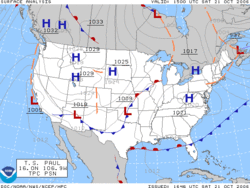
On a weather map warm fronts are shown as red lines with red semicircles pointing in the direction that the front is moving.
Warm Front Media
Illustration of a warm front. The warm air behind the front is slowly overtaking the cold air ahead of the front, which is moving more slowly in the same direction. The warmer air, due to lower density, rises over the colder air as it moves. As a result of its increased altitude, it cools off and its moisture condenses, forming clouds and possibly precipitation.
A surface weather analysis for the United States on October 21, 2006. Note the warm front in the northwest Gulf of Mexico.
References
- ↑ Warm Front: transition zone from cold air to warm air
- ↑ "Warm Fronts". Archived from the original on 2007-12-26. Retrieved 2009-08-14.
- ↑ Warm fronts are not as nice as they sound[dead link]


