Nautical chart

A nautical chart is a map which is used to show objects on the ocean. Nautical charts were very common from the 14th century to the 17th century. They are usually used by sailors to navigate.
Nautical Chart Media

A nautical chart of the Warnemünde harbor shown on OpenSeaMap
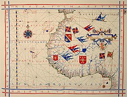
A pre-Mercator nautical chart of 1571, from Portuguese cartographer Fernão Vaz Dourado (c. 1520 – c. 1580). It belongs to the so-called plane chart model, where observed latitudes and magnetic directions are plotted directly into the plane, with a constant scale, as if the Earth's surface were a flat plane (Portuguese National Archives of Torre do Tombo, Lisbon)

Portion of an electronic chart of the Bering Strait

Automatically labeled nautical chart

Detail of a United States NOAA chart, showing a harbour area

Use of colour in British Admiralty charts


