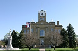
Albia, Iowa
Albia is a city in Iowa in the United States.
 | |
 Location within Monroe County and Iowa | |
| Coordinates: 41°01′35″N 92°48′14″W / 41.02639°N 92.80389°WCoordinates: 41°01′35″N 92°48′14″W / 41.02639°N 92.80389°W | |
| Country | United States |
| State | Iowa |
| County | Monroe |
| Area | |
| • Total | 3.23 sq mi (8.37 km2) |
| • Land | 3.23 sq mi (8.37 km2) |
| • Water | 0.00 sq mi (0.00 km2) |
| Elevation | 961 ft (293 m) |
| Population | |
| • Total | 3,721 |
| • Density | 1,151.30/sq mi (444.50/km2) |
| Time zone | UTC-6 (Central (CST)) |
| • Summer (DST) | UTC-5 (CDT) |
| ZIP code | 52531 |
| FIPS code | 19-00910 |
| GNIS feature ID | 2393905[2] |
| Website | www |
Albia, Iowa Media
References
- ↑ "2020 U.S. Gazetteer Files". United States Census Bureau. Retrieved March 16, 2022.
- ↑ 2.0 2.1 U.S. Geological Survey Geographic Names Information System: Albia, Iowa
- ↑ "Albia city, Iowa". United States Census Bureau. Retrieved October 30, 2023.


