Armington, Illinois
Armington is a village in Tazwell County, Illinois in the United States. The population was 310 at the 2020 census.[2] It is part of the Peoria, Illinois Metropolitan Statistical Area.
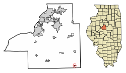
 Location of Armington in Tazewell County, Illinois. | |
 Location of Illinois in the United States | |
| Coordinates: 40°20′21″N 89°18′49″W / 40.33917°N 89.31361°WCoordinates: 40°20′21″N 89°18′49″W / 40.33917°N 89.31361°W | |
| Country | United States |
| State | Illinois |
| County | Tazewell |
| Area | |
| • Total | 0.29 sq mi (0.74 km2) |
| • Land | 0.29 sq mi (0.74 km2) |
| • Water | 0.00 sq mi (0.00 km2) |
| Elevation | 627 ft (191 m) |
| Population | |
| • Total | 310 |
| • Density | 1,087.72/sq mi (420.19/km2) |
| Time zone | UTC-6 (CST) |
| • Summer (DST) | UTC-5 (CDT) |
| ZIP Code(s) | 61721 |
| FIPS code | 17-02206 |
Geography
Armington is located at 40°20′21″N 89°18′49″W / 40.33917°N 89.31361°W (40.339078, -89.313741).[3] According to the 2020 census, Armington has a total area of 0.29 square miles (0.74 km2), which is all land.[1]
References
- ↑ 1.0 1.1 "2020 U.S. Gazetteer Files". United States Census Bureau. Retrieved March 15, 2022.
- ↑ 2.0 2.1 "Armington village, Illinois". United States Census Bureau. Retrieved September 23, 2023.
- ↑ Bureau, US Census. "Gazetteer Files". Census.gov. Retrieved 2022-10-22.