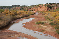
Brazos River
The Brazos River (/ˈbræzəs/ (File:Speaker Icon.svg listen) BRAZ-əs), called the Río de los Brazos de Dios (translated as "The River of the Arms of God") by early Spanish explorers, is the 11th-longest river in the United States at 1,280 miles (2,060 km). Its source is at the head of Blackwater Draw, Curry County, New Mexico[1] to its mouth at the Gulf of Mexico with a 45,000-square-mile (116,000 km2) drainage basin.[2]
| Brazos River | |
|---|---|
| Mouth | Gulf of Mexico |
| Length | 1,352 km (840 mi) |
| Mouth elevation | 0 m (0 ft) |
It is one of Texas' largest rivers.[3]
Brazos River Media
An advertisement for the steamboat Yellow Stone, December 1836. Packet service between Quintana and Washington, Republic of Texas.
North Fork Double Mountain Fork Brazos River at the edge of the Llano Estacado
Double Mountain Fork Brazos River at the site of former Rath City, Texas
The Brazos in north Central Texas
- Brazos River west of Bryan, TX IMG 0551.JPG
The Brazos in southeast Central Texas west of Bryan, Texas
References
- ↑ Kammerer, J.C. (1987). "Largest Rivers in the United States". United States Geological Survey. Retrieved 2006-07-15.
{{cite journal}}: Cite journal requires|journal=(help) - ↑ Hendrickson Kenneth E., Jr. (1999-02-15). "Brazos River". The Handbook of Texas Online. The General Libraries at the University of Texas at Austin and the Texas State Historical Association. Archived from the original on July 10, 2011. Retrieved 2006-07-22.
- ↑ "Brazos River." Britannica Academic, Encyclopædia Britannica, 11 Aug. 2018. academic.eb.com/levels/collegiate/article/Brazos-River/16291. Accessed 27 Nov. 2018.


