Canterbury Region
Canterbury (Māori: [Waitaha] Error: {{Lang}}: text has italic markup (help)) is one of the 16 regions of New Zealand. It is on the South Island. Its largest city is Christchurch.
|
Waitaha | |
|---|---|
| Canterbury Region | |
 Canterbury Region within New Zealand | |
| Coordinates: 43°36′S 172°00′E / 43.6°S 172.0°ECoordinates: 43°36′S 172°00′E / 43.6°S 172.0°E | |
| Country | New Zealand |
| Island | South Island |
| Established | 1989 |
| Seat | Christchurch |
| Territorial authorities | List
|
| Government | |
| • Chairperson | Peter Scott |
| Area | |
| • Land | 44,503.88 km2 (17,183.04 sq mi) |
| Population (June 2022)[1] | |
| • Region | 655,000 |
| Time zone | UTC+12 (NZST) |
| • Summer (DST) | UTC+13 (NZDT) |
| HDI (2021) | 0.938[2] very high · 4th |
Canterbury Region Media
Building damage in Worcester Street, corner Manchester Street, with ChristChurch Cathedral in the background. (September 2010)
ChristChurch Cathedral showing the effects of the February 2011 earthquake (tower under demolition)
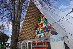
The Cardboard Cathedral in Christchurch opened in August 2013 as the transitional pro-cathedral for the Anglican Diocese of Christchurch. Anglicans make up 14.8 percent of Canterbury's population.
Crossing the Macauley River, Lilybank Station, Canterbury, New Zealand, 1977.
References
- ↑ "Subnational population estimates (RC, SA2), by age and sex, at 30 June 1996-2022 (2022 boundaries)". Statistics New Zealand. Retrieved 25 October 2022. (regional councils); "Subnational population estimates (TA, SA2), by age and sex, at 30 June 1996-2022 (2022 boundaries)". Statistics New Zealand. Retrieved 25 October 2022. (territorial authorities); "Subnational population estimates (urban rural), by age and sex, at 30 June 1996-2022 (2022 boundaries)". Statistics New Zealand. Retrieved 25 October 2022. (urban areas)
- ↑ "Sub-national HDI – Area Database – Global Data Lab". hdi.globaldatalab.org. Retrieved 2018-09-13.


