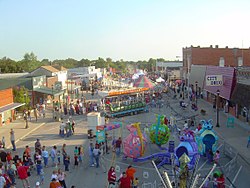
Coweta, Oklahoma
Coweta is a city in Wagoner County, Oklahoma and is a suburb of Tulsa. The population was 9,654 at the 2020 census.[4]
 | |
| Location of Coweta, Oklahoma Location of Coweta, Oklahoma | |
| Coordinates: 35°57′47″N 95°39′42″W / 35.96306°N 95.66167°WCoordinates: 35°57′47″N 95°39′42″W / 35.96306°N 95.66167°W | |
| Country | United States |
| State | Oklahoma |
| County | Wagoner |
| Area | |
| • Total | 10.71 sq mi (27.73 km2) |
| • Land | 10.58 sq mi (27.41 km2) |
| • Water | 0.12 sq mi (0.32 km2) |
| Elevation | 663 ft (202 m) |
| Population (2020) | |
| • Total | 9,654 |
| • Density | 912.13/sq mi (352.16/km2) |
| Time zone | UTC-6 (Central (CST)) |
| • Summer (DST) | UTC-5 (CDT) |
| ZIP code | 74429 |
| FIPS code | 40-17800[2] |
| GNIS feature ID | 1091781[3] |
| Website | City of Coweta |
History
Before statehood, when the Five Tribes or Five Civilized Tribes were moved to Oklahoma from the Eastern United States, the area that is now Coweta became part of the Creek Nation. Coweta was named after a Creek Indian war town on the Chattahoochee River in southwestern Georgia and was first settled by American Indians about 1840. In 1843 Robert Loughridge arrived in the area and established a mission, named "Koweta".
In 1867 after the Civil War, the Creek Indians adopted a constitution which divided there nation into six districts. Everything northeast of the Arkansas River, including Tulsa, became the Coweta district. The political center of this district was in a log courthouse on Coweta Creek, about a one-fourth of a mile west from the modern day center of the downtown Coweta. The Post Office was established on May 24, 1897, and was named after the Koweta Mission.[5]
Many notable events occurred in 1903. Along with the arrival of the Missouri-Kansas-Texas Railroad, Coweta’s first newspaper, The Courier, was started, the first school was built, and a telephone line was put in.
Geography
Coweta is at (35.963155, -95.661586).
According to the United States Census Bureau, the city has a total area of 10.7 square miles (27.6 km²), of which, 10.5 square miles (27.3 km²) of it is land and 0.1 square miles (0.3 km²) of it (1.1%) is water.[6]
Historical sites
Coweta is home to two sites on the National Register of Historic Places list. The first is the Koweta Mission Site. The mission was added to the NRHP in 1973, today only a cemetery remains. The second historical site in Coweta is the First Presbyterian Church of Coweta, commonly known as the Mission Bell Museum. The Mission Bell Museum was added to the NRHP in 2003 and is owned and operated by the city of Coweta.
Coweta, Oklahoma Media
- Mission Bell Museum.jpg
The Coweta Mission Bell Museum.
References
- ↑ "ArcGIS REST Services Directory". United States Census Bureau. Retrieved September 20, 2022.
- ↑ "U.S. Census website". United States Census Bureau. Retrieved 2008-01-31.
- ↑ "US Board on Geographic Names". United States Geological Survey. 2007-10-25. Retrieved 2008-01-31.
- ↑ "DP1: PROFILE OF GENERAL POPULATION AND HOUSING CHARACTERISTICS". United States Census Bureau. Retrieved January 28, 2024.
- ↑ "How places got their names". Oklahoma Historical Society. Archived from the original on 2008-09-19. Retrieved 2008-01-18.
- ↑ "2020 U.S. Gazetteer Files". United States Census Bureau. Retrieved January 28, 2024.
Other websites
- History of Coweta Archived 2006-09-28 at the Wayback Machine
- City of Coweta Archived 2006-09-28 at the Wayback Machine
- Coweta Public Schools Archived 2008-05-12 at the Wayback Machine