File:2020aug-derecho-storm-crop-overlay-usda-map.png
No higher resolution available.
2020aug-derecho-storm-crop-overlay-usda-map.png (705 × 545 pixels, file size: 406 KB, MIME type: image/png)
| This is a file from the Wikimedia Commons. The description on its description page there is shown below.
|
Summary
| Description |
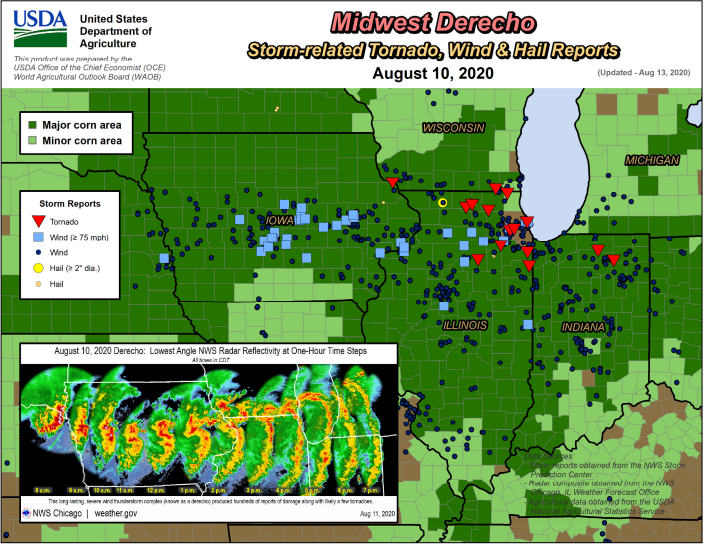
English: A map of the Midwest United States focusing on Iowa, Illinois, and Indiana. Storm reports from the w:August 2020 Midwest derecho are layered over the w:USDA analysis of corn production areas. |
| Date | |
| Source |
USDA Weekly Weather and Crop Bulletin - Vol. 107 No. 33 - August 18, 2020 - https://downloads.usda.library.cornell.edu/usda-esmis/files/cj82k728n/3t946c39r/w6634s119/wwcb3320.pdf National Weather Service (Des Moines Office) - https://www.weather.gov/dmx/2020derecho |
| Author | United States Department of Agriculture, National Oceanic and Atmospheric Administration, National Weather Service |
Licensing
This image or file is a work of a United States Department of Agriculture employee, taken or made as part of that person's official duties. As a work of the U.S. federal government, the image is in the public domain.
|
 |
This image is in the public domain because it was stored on the web servers of the U.S. National Weather Service. NWS-created images are automatically public domain in the U.S. since the NWS is a part of the U.S. government. However, the NWS sites also host non-NWS images which have been submitted by individuals: these are generally shown as "Courtesy of ...". Such images have explicitly been released to the public domain by the copyright owner as part of the upload process.
As stated at https://www.weather.gov/fsd/disclaimer: "By submitting images, you understand that your image is being released into the public domain. This means that your photo or video may be downloaded, copied, and used by others." Thus, all* images on NWS servers are public domain (including "Courtesy of ..." and “Photo by ...” images) unless specifically stated otherwise through a copyright (©) watermark.
*A deletion discussion in November 2023 ruled that Getty Images on the web servers of NWS, are to be considered copyrighted, even without a copyright (©) watermark and are the sole exception to this rule.
|
File history
Click on a date/time to view the file as it appeared at that time.
| Date/Time | Dimensions | User | Comment | |
|---|---|---|---|---|
| current | 02:03, 27 August 2020 | 705 × 545 (406 KB) | Gwennie-nyan | Uploaded a work by United States Department of Agriculture, National Oceanic and Atmospheric Administration, National Weather Service from USDA Weekly Weather and Crop Bulletin - Vol. 107 No. 33 - August 18, 2020 - https://downloads.usda.library.cornell.edu/usda-esmis/files/cj82k728n/3t946c39r/w6634s119/wwcb3320.pdf National Weather Service (Des Moines Office) - https://www.weather.gov/dmx/2020derecho with UploadWizard |
File usage
The following page uses this file: