File:AIS Manche Est.png

Size of this preview: 800 × 396 pixels. Other resolutions: 320 × 158 pixels | 920 × 455 pixels.
Original file (920 × 455 pixels, file size: 46 KB, MIME type: image/png)
| This is a file from the Wikimedia Commons. The description on its description page there is shown below.
|
Summary
| Description |
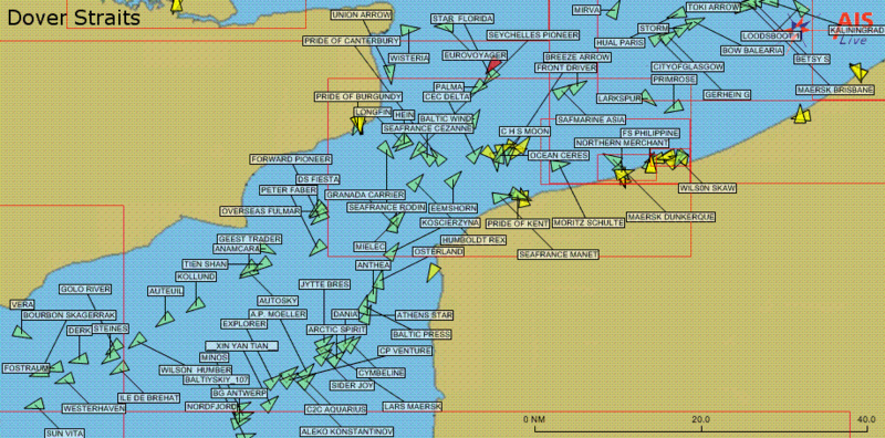
English: Display of maritime traffic provided by AIS. Only vessels equipped with AIS are displayed, which excludes most fishing boats, pleasure craft, inland navigation and vessels less than 300 tons. Location: Dover Straits/English Channel.
Français : Affichage du trafic maritime fourni par le système AIS. Seuls les navires équipés du dispositif AIS sont affichés ce qui exclut la plupart des bateaux de pêche et de plaisance ainsi que les cargos n'effectuant que du transport domestique et de moins de 300 tonneaux. Lieu: Manche Est. |
| Date | |
| Source | Own work |
| Author | fr:User:Pline |
Licensing
| |
This work has been released into the public domain by its author, Pline, at the English Wikipedia project. This applies worldwide. In case this is not legally possible: |
Original upload
Image originally uploaded by fr:User:Pline on fr.wikipedia. Transferred to commons by User:Korrigan on 23 January 2006.
File history
Click on a date/time to view the file as it appeared at that time.
| Date/Time | Dimensions | User | Comment | |
|---|---|---|---|---|
| current | 03:20, 2 February 2013 | 920 × 455 (46 KB) | Jahoe | cropped border |
File usage
The following 2 pages use this file: