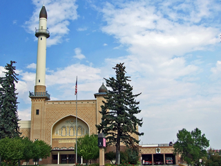
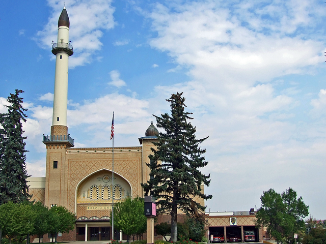
File:Algeria Shrine Temple (2012) - Lewis and Clark County, Montana.png

Size of this preview: 800 × 600 pixels. Other resolutions: 320 × 240 pixels | 640 × 480 pixels | 1,024 × 768 pixels | 1,280 × 960 pixels | 1,600 × 1,200 pixels.
Original file (1,600 × 1,200 pixels, file size: 3.34 MB, MIME type: image/png)
| This is a file from the Wikimedia Commons. The description on its description page there is shown below.
|
_-_Lewis_and_Clark_County,_Montana.png)
Summary
| Camera location | | View this and other nearby images on: OpenStreetMap |
|---|
_-_Lewis_and_Clark_County,_Montana.png¶ms=046.595278_N_-112.039167_E_globe:Earth_type:camera__&language=en)
| Description |
English: Algeria Shrine Temple, The Algeria Shrine Temple, completed in 1921, was built by the Ancient Arabic Order of the Nobles of the Mystic Shrine both for their use and for public events in Helena. George S. Carsley and Charles S. Haire, prominent architects of the era, designed this Moorish Revival building. Its minaret rises seventeen stories, and its façade six. Upon completion, the auditorium was ninth-largest in the nation, seating 2,608 people. The ballroom accommodates 500 dancing couples. The fire station, a 1939 addition, carries out the polychromatic design of the exterior brick. Severe damage by earthquakes in 1935 was beyond the financial means of the local Shrine to repair, yet the facility remained in demand for public use. The City of Helena purchased this structure in 1938, when it became the Civic Center, housing city government departments until 1979. The citizens of Helena, through local government and a Civic Center Advisory Board, have worked for the renovation and preservation of this building that serves many cultural needs of the Helena community.
|
||
| Date | |||
| Source | Own work | ||
| Author | Robstutz |
Licensing
I, the copyright holder of this work, hereby publish it under the following license:
This file is licensed under the Creative Commons Attribution-Share Alike 3.0 Unported license.
- You are free:
- to share – to copy, distribute and transmit the work
- to remix – to adapt the work
- Under the following conditions:
- attribution – You must give appropriate credit, provide a link to the license, and indicate if changes were made. You may do so in any reasonable manner, but not in any way that suggests the licensor endorses you or your use.
- share alike – If you remix, transform, or build upon the material, you must distribute your contributions under the same or compatible license as the original.

|
This image was uploaded as part of Wiki Loves Monuments 2012.
|
 |
File history
Click on a date/time to view the file as it appeared at that time.
| Date/Time | Dimensions | User | Comment | |
|---|---|---|---|---|
| current | 15:35, 9 September 2012 | 1,600 × 1,200 (3.34 MB) | Robstutz | User created page with UploadWizard |
File usage
The following page uses this file:
_-_Lewis_and_Clark_County,_Montana.png)