File:Buddha Dhatu Jadi DJI 0249-1.jpg

Size of this preview: 800 × 533 pixels. Other resolutions: 320 × 213 pixels | 640 × 426 pixels | 1,024 × 682 pixels | 1,280 × 853 pixels | 5,039 × 3,357 pixels.
Original file (5,039 × 3,357 pixels, file size: 10 MB, MIME type: image/jpeg)
| This is a file from the Wikimedia Commons. The description on its description page there is shown below.
|
Summary
| Description |
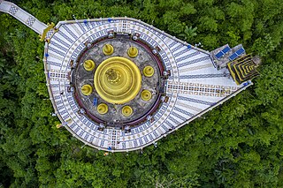
বাংলা: বুদ্ধ ধাতু জাদি
English: Buddha Dhatu Jadi, Bandorban
|
||
| Date | |||
| Source | Own work | ||
| Author | Azim Khan Ronnie |
| Camera location | | View this and other nearby images on: OpenStreetMap |
|---|
Assessment
|
This image was selected as picture of the day on Bengali Wikipedia.
|

|
This image was awarded with the 1st prize in the national contest of Bangladesh in Wiki Loves Monuments 2020 Other languages:
|
This image was selected as picture of the day on Wikimedia Commons for 4 March 2023. It was captioned as follows: Other languages:
Čeština: Budhistický chrám Buddha Dhatu Jadi v oblasti Bandarban v Bangladéši při pohledu ze vzduchu. Deutsch: Luftaufnahme des Dhatu Jadi Buddha, dem Goldenen Tempel von Bandorban in Bangladesch. Français : Vue aérienne du Buddha Dhatu Jadi, temple bouddhiste de Bandarban (Bangladesh). Magyar: A Buddha Dhátu Dzsádi légi felvétele (Bándarbán, Banglades) Nederlands: Luchtfoto van de Gouden Tempel in het Bengaalse district Bandarban Português: Vista aérea do Templo Dourado de Bandarban, Bangladesh. বাংলা : বুদ্ধ ধাতু জাদির আন্তরীক্ষ দৃশ্য। এটি বান্দরবান স্বর্ণ মন্দির নামেও সুপরিচিত। এটি বাংলাদেশের বান্দরবান শহরের বালাঘাটা এলাকায় অবস্থিত। |

|
This image was uploaded as part of Wiki Loves Monuments 2020.
|
 |
Licensing
I, the copyright holder of this work, hereby publish it under the following license:
This file is licensed under the Creative Commons Attribution-Share Alike 4.0 International license.
- You are free:
- to share – to copy, distribute and transmit the work
- to remix – to adapt the work
- Under the following conditions:
- attribution – You must give appropriate credit, provide a link to the license, and indicate if changes were made. You may do so in any reasonable manner, but not in any way that suggests the licensor endorses you or your use.
- share alike – If you remix, transform, or build upon the material, you must distribute your contributions under the same or compatible license as the original.
File history
Click on a date/time to view the file as it appeared at that time.
| Date/Time | Dimensions | User | Comment | |
|---|---|---|---|---|
| current | 10:28, 26 November 2020 | 5,039 × 3,357 (10 MB) | Azimronnie | Uploaded own work with UploadWizard |
File usage
The following page uses this file: