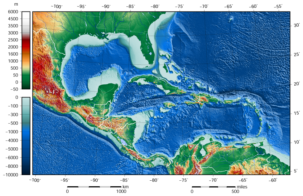
File:Caribbean Sea Gulf of Mexico shaded relief bathymetry land map.png
Original file (1,024 × 664 pixels, file size: 1.1 MB, MIME type: image/png)
| This is a file from the Wikimedia Commons. The description on its description page there is shown below.
|
Summary
| Description |
English: The shaded relief bathymetry and land map of the Caribbean Sea and Gulf of Mexico area. The map was created using the Generic Mapping Tools, GMT, version 5.1.1. |
| Date | |
| Source |
Own work using: the following Public Domain datasets for the relief:
|
| Author | Darekk2 using the ETOPO1 and GLOBE tiles |
| Other versions |
The same image but contoured at -100 m: |

Licensing
Attribution (in addition to the author of this map):
The NGDC in it's copyright notice says:
As required by 17 U.S.C. 403, third parties producing copyrighted works consisting predominantly of the material produced by U.S. government agencies must provide notice with such work(s) identifying the U.S. Government material incorporated and stating that such material is not subject to copyright protection within the United States. (...)
(for credits see the Source section).
and GLOBE and ETOPO1
(see above and the Source section)
- You are free:
- to share – to copy, distribute and transmit the work
- to remix – to adapt the work
- Under the following conditions:
- attribution – You must give appropriate credit, provide a link to the license, and indicate if changes were made. You may do so in any reasonable manner, but not in any way that suggests the licensor endorses you or your use.
- share alike – If you remix, transform, or build upon the material, you must distribute your contributions under the same or compatible license as the original.
File history
Click on a date/time to view the file as it appeared at that time.
| Date/Time | Dimensions | User | Comment | |
|---|---|---|---|---|
| current | 02:58, 8 June 2015 | 1,024 × 664 (1.1 MB) | Darekk2 | added lakes ... and changed palette for land (white highest mountains) |
File usage
The following 2 pages use this file: