File:EasternBloc.png
Size of this preview: 369 × 599 pixels. Other resolutions: 148 × 240 pixels | 396 × 643 pixels.
Original file (396 × 643 pixels, file size: 84 KB, MIME type: image/png)
| This is a file from the Wikimedia Commons. The description on its description page there is shown below.
|
Summary
| Description |
English:
The border and other changes include:
|
| Source | |
| Author |
Licensing

|
Permission is granted to copy, distribute and/or modify this document under the terms of the GNU Free Documentation License, Version 1.2 or any later version published by the Free Software Foundation; with no Invariant Sections, no Front-Cover Texts, and no Back-Cover Texts. A copy of the license is included in the section entitled GNU Free Documentation License. |
| This file is licensed under the Creative Commons Attribution-Share Alike 3.0 Unported license. | ||
| ||
| This licensing tag was added to this file as part of the GFDL licensing update. |
Original upload log
The original description page was here. All following user names refer to en.wikipedia.
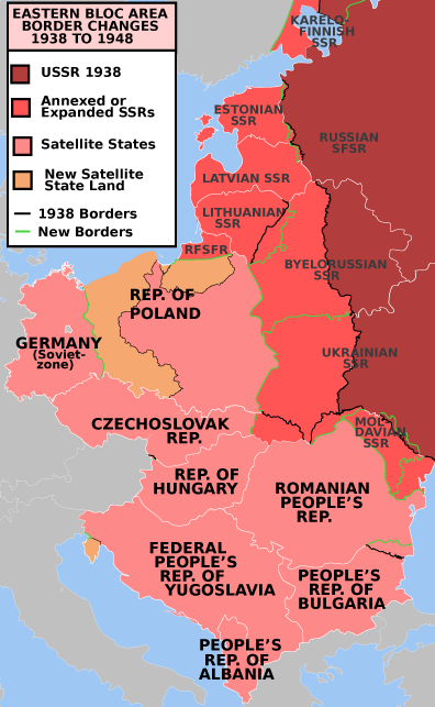
- 2009-03-04 23:00 Mosedschurte 622×634× (158695 bytes) * Description: The Eastern Bloc - Green lines are 1938 borders, black lines are reset 1946 borders. Dark red is the Russian SFSR, light red are annexed Soviet Socialist Republics and pink are Soviet satellite Peoples Republics. * Source: Own map, based o
- 2009-03-04 20:39 Mosedschurte 607×633× (102858 bytes) * Description: The Eastern Bloc - Green lines are 1938 borders, black lines are reset 1946 borders. Dark red is the Russian SFSR, light red are annexed Soviet Socialist Republics and pink are Soviet satellite Peoples Republics. * Source: Own map, based o
- 2009-03-03 11:26 Mosedschurte 602×637× (157934 bytes) * Description: The Eastern Bloc - Green lines are 1938 borders, black lines are reset 1946 borders. Dark red is the Russian SFSR, light red are annexed Soviet Socialist Republics and pink are Soviet satellite Peoples Republics. * Source: Own map, based o
- 2009-03-03 02:40 Mosedschurte 619×638× (106577 bytes) * Description: The Eastern Bloc - Green lines are 1938 borders, black lines are reset 1946 borders. Dark red is the Russian SFSR, light red are annexed Soviet Socialist Republics and pink are Soviet satellite Peoples Republics. * Source: Own map, based o
- 2009-03-03 01:45 Mosedschurte 602×647× (105925 bytes) * Description: The Eastern Bloc - Green lines are 1938 borders, black lines are reset 1946 borders. Dark red is the Russian SFSR, light red are annexed Soviet Socialist Republics and pink are Soviet satellites. * Source: Own map, based o
File history
Click on a date/time to view the file as it appeared at that time.
| Date/Time | Dimensions | User | Comment | |
|---|---|---|---|---|
| current | 14:22, 7 June 2009 | 396 × 643 (84 KB) | Mosedschurte | * Description: Former Eastern Bloc area border changes between 1938 and 1948. * Source: Map borders primarily based on [http://commons.wikimedia.org/wiki/File:EC12-1986_European_Community_map.svg] and [http://commons.wikimedia.org/wiki/File:Blank_map_ |
File usage
The following page uses this file: