File:Free Imperial Cities 1792.png

Size of this preview: 696 × 599 pixels. Other resolutions: 279 × 240 pixels | 558 × 480 pixels | 697 × 600 pixels | 892 × 768 pixels | 1,190 × 1,024 pixels | 1,545 × 1,330 pixels.
Original file (1,545 × 1,330 pixels, file size: 439 KB, MIME type: image/png)
| This is a file from the Wikimedia Commons. The description on its description page there is shown below.
|
Summary
| Description |
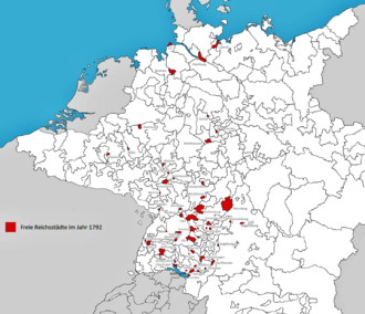
English: The Free Imperial Cities of the Holy Roman Empire in 1792. The map shows the 50 cities that took part in the assembly of the Imperial Diet that year, plus Buchau and Gelnhausen. Not shown are the many enclaves and exclaves, with the exception of Cuxhaven, the distant exclave of Hamburg located at the mouth of the Elbe River. |
| Date | |
| Source | Own work |
| Author | Lubiesque |
Licensing
I, the copyright holder of this work, hereby publish it under the following license:
This file is licensed under the Creative Commons Attribution-Share Alike 4.0 International license.
- You are free:
- to share – to copy, distribute and transmit the work
- to remix – to adapt the work
- Under the following conditions:
- attribution – You must give appropriate credit, provide a link to the license, and indicate if changes were made. You may do so in any reasonable manner, but not in any way that suggests the licensor endorses you or your use.
- share alike – If you remix, transform, or build upon the material, you must distribute your contributions under the same or compatible license as the original.
File history
Click on a date/time to view the file as it appeared at that time.
| Date/Time | Dimensions | User | Comment | |
|---|---|---|---|---|
| current | 04:29, 11 August 2015 | 1,545 × 1,330 (439 KB) | Lubiesque | Image contrast. Easier to read. |
File usage
The following page uses this file: