File:Gubernie zachodnie krolestwo polskie 1902.jpg
Size of this preview: 461 × 599 pixels. Other resolutions: 185 × 240 pixels | 369 × 480 pixels | 462 × 600 pixels | 591 × 768 pixels | 788 × 1,024 pixels | 2,500 × 3,247 pixels.
Original file (2,500 × 3,247 pixels, file size: 2.21 MB, MIME type: image/jpeg)
| This is a file from the Wikimedia Commons. The description on its description page there is shown below.
|
Summary
| Description |
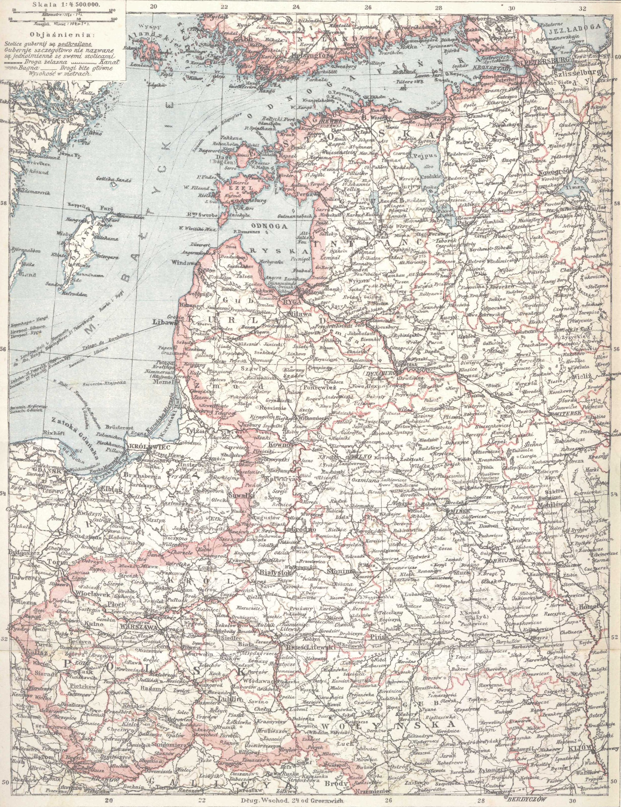
English: Western Governorships of the Russian Empire and Polish Kingdom in 1902. Map from Olgebrand's Encyclopedia (lithography) printed in Warszawa, 1902
Polski: Mapa "Gubernie Zachodnie i Królestwo Polskie" z encyklopedii Samuela Orgelbranda z r. 1902 - litografia |
|||||||||
| Date | ||||||||||
| Source | pl:S._Orgelbranda_Encyklopedia_Powszechna_(1898) | |||||||||
| Geotemporal data | ||||||||||
| Date depicted | ||||||||||
| Map location | Western Governorships of the Russian Empire, Polish Kingdom | |||||||||
| Bounding box |
|
|||||||||
| Georeferencing | ||||||||||
| Bibliographic data | ||||||||||
| Language | Polish | |||||||||
Licensing
scanned by myself
| source: Samuel Orgelbrand's Universal Encyclopedia with illustrations and maps
edited in sixteen volumes 1898–1904 (plus two volumes of "suplement", 1911 & 1912) |
|
This work is in the public domain in its country of origin and other countries and areas where the copyright term is the author's life plus 100 years or fewer. This work is in the public domain in the United States because it was published (or registered with the U.S. Copyright Office) before January 1, 1929. | |
| This file has been identified as being free of known restrictions under copyright law, including all related and neighboring rights. | |
File history
Click on a date/time to view the file as it appeared at that time.
| Date/Time | Dimensions | User | Comment | |
|---|---|---|---|---|
| current | 16:20, 19 July 2010 | 2,500 × 3,247 (2.21 MB) | Beao | Removed border. |
File usage
The following page uses this file: