File:Kyushumap-en.png
Size of this preview: 338 × 600 pixels. Other resolutions: 135 × 240 pixels | 631 × 1,120 pixels.
Original file (631 × 1,120 pixels, file size: 389 KB, MIME type: image/png)
| This is a file from the Wikimedia Commons. The description on its description page there is shown below.
|
Summary
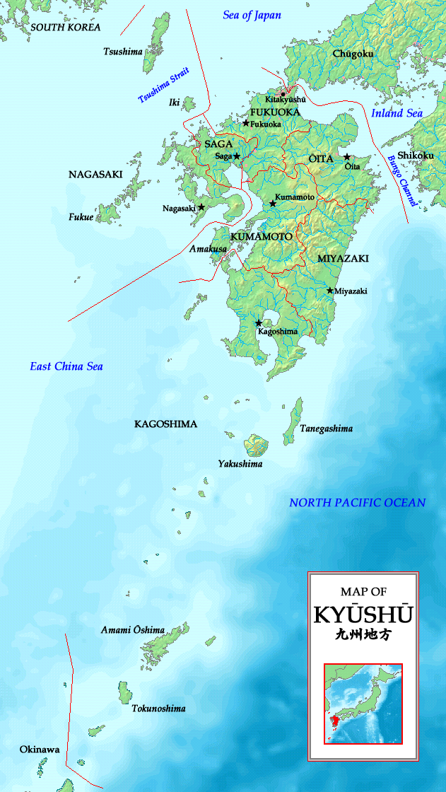
| Description | A map of the Kyūshū region (九州地方) with major islands, Kitakyūshū, prefectures and prefectural capitals indicated |
| Date | |
| Source | Own work |
| Author | Zakuragi |
| Other versions | Derivative works of this file: Omura-yama on Kyushu map-en.jpg |
Licensing
I, the copyright holder of this work, hereby publish it under the following licenses:

|
Permission is granted to copy, distribute and/or modify this document under the terms of the GNU Free Documentation License, Version 1.2 or any later version published by the Free Software Foundation; with no Invariant Sections, no Front-Cover Texts, and no Back-Cover Texts. A copy of the license is included in the section entitled GNU Free Documentation License. |
| This file is licensed under the Creative Commons Attribution-Share Alike 3.0 Unported license. | ||
| ||
| This licensing tag was added to this file as part of the GFDL licensing update. |
This file is licensed under the Creative Commons Attribution-Share Alike 2.5 Generic, 2.0 Generic and 1.0 Generic license.
- You are free:
- to share – to copy, distribute and transmit the work
- to remix – to adapt the work
- Under the following conditions:
- attribution – You must give appropriate credit, provide a link to the license, and indicate if changes were made. You may do so in any reasonable manner, but not in any way that suggests the licensor endorses you or your use.
- share alike – If you remix, transform, or build upon the material, you must distribute your contributions under the same or compatible license as the original.
You may select the license of your choice.
This image is in the public domain because it came from the site https://www.demis.nl/products/web-map-server/examples/ and was released by the copyright holder. Permission is granted to copy, distribute and/or modify this map since it is based on free of copyright images from: www.demis.nl. See also approval email on de.wp and its clarification.
|
| This work has been released into the public domain by its copyright holder, www.demis.nl. This applies worldwide. In some countries this may not be legally possible; if so: www.demis.nl grants anyone the right to use this work for any purpose, without any conditions, unless such conditions are required by law.
|
File history
Click on a date/time to view the file as it appeared at that time.
| Date/Time | Dimensions | User | Comment | |
|---|---|---|---|---|
| current | 08:49, 20 May 2007 | 631 × 1,120 (389 KB) | Tonym88~commonswiki | {{Information |Description= A map of the Kyūshū region (九州地方) with major islands, Kitakyūshū, prefectures and prefectural capitals indicated |Source= Self-made |Date= May 20, 2007 |Author= Zakuragi }} == Licensing == {{self2|GFDL|cc-by-sa-2. |
File usage
The following page uses this file: