File:Louisiane 1800.png
No higher resolution available.
Louisiane_1800.png (383 × 329 pixels, file size: 9 KB, MIME type: image/png)
| This is a file from the Wikimedia Commons. The description on its description page there is shown below.
|
Summary

|
This locator map image could be re-created using vector graphics as an SVG file. This has several advantages; see Commons:Media for cleanup for more information. If an SVG form of this image is available, please upload it and afterwards replace this template with
{{vector version available|new image name}}.
It is recommended to name the SVG file “Louisiane 1800.svg”—then the template Vector version available (or Vva) does not need the new image name parameter. |
| Description |
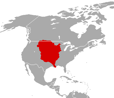
English: The Louisiana Territory as it was from 1763 to 1803.
Français : Le territoire de Louisiane tel qu'il l'était de 1763 à 1803.
Español: La Louisiana Territorio como lo fue desde 1763 a 1803. |
| Date | |
| Source | File:LouisianaPurchase.png |
| Author | Unknown author |
Licensing

|
Permission is granted to copy, distribute and/or modify this document under the terms of the GNU Free Documentation License, Version 1.2 or any later version published by the Free Software Foundation; with no Invariant Sections, no Front-Cover Texts, and no Back-Cover Texts. A copy of the license is included in the section entitled GNU Free Documentation License. |
| This file is licensed under the Creative Commons Attribution-Share Alike 3.0 Unported license. | ||
| ||
| This licensing tag was added to this file as part of the GFDL licensing update. |
Original upload log
(All user names refer to fr.wikipedia)
- 2003-09-01 20:34 F5ZV 412×306×8 (7986 bytes) carte de la Louisiane en 1800 au moment de la vente par Napoléon aux Etats-Unis.
File history
Click on a date/time to view the file as it appeared at that time.
| Date/Time | Dimensions | User | Comment | |
|---|---|---|---|---|
| current | 17:57, 15 December 2010 | 383 × 329 (9 KB) | Maps & Lucy | fixed the border along New Spain and changed colour to Spanish Red due to it being a territory of New Spain |
File usage
The following page uses this file: