File:Map of New Mexico highlighting Doña Ana County.svg

Size of this PNG preview of this SVG file: 539 × 599 pixels. Other resolutions: 216 × 240 pixels | 432 × 480 pixels | 540 × 600 pixels | 691 × 768 pixels | 921 × 1,024 pixels | 5,677 × 6,312 pixels.
Original file (SVG file, nominally 5,677 × 6,312 pixels, file size: 35 KB)
| This is a file from the Wikimedia Commons. The description on its description page there is shown below.
|
Summary
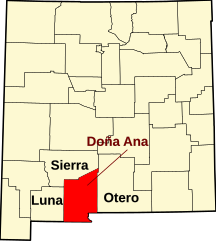
- Locator map showing Dona Ana County in southern New Mexico, U.S.
- Credits
- David Benbennick made this map.
- For more information, see Commons:United States county locator maps.
- Or see any of the New Mexico county locator maps: Bernalillo ·
Catron · Chaves · Cibola · Colfax · Curry · De Baca · Doña Ana · Eddy · Grant · Guadalupe · Harding · Hidalgo · Lea · Lincoln · Los Alamos · Luna · McKinley · Mora · Otero · Quay · Rio Arriba · Roosevelt · Sandoval · San Juan · San Miguel · Santa Fe · Sierra · Socorro · Taos · Torrance · Union · Valencia.
| This work has been released into the public domain by its author, Dbenbenn. This applies worldwide. In some countries this may not be legally possible; if so: |
en:Category:Dona Ana County, New Mexico
File history
Click on a date/time to view the file as it appeared at that time.
| Date/Time | Dimensions | User | Comment | |
|---|---|---|---|---|
| current | 04:30, 17 April 2009 | 5,677 × 6,312 (35 KB) | Rfc1394 | Add labels of adjacent counties with big font (350 px) |
File usage
The following page uses this file: