File:Map of the Crimea.png

Size of this preview: 800 × 520 pixels. Other resolutions: 320 × 208 pixels | 640 × 416 pixels | 1,024 × 666 pixels | 1,280 × 833 pixels | 2,283 × 1,485 pixels.
Original file (2,283 × 1,485 pixels, file size: 984 KB, MIME type: image/png)
| This is a file from the Wikimedia Commons. The description on its description page there is shown below.
|
Summary

|
This map image could be re-created using vector graphics as an SVG file. This has several advantages; see Commons:Media for cleanup for more information. If an SVG form of this image is available, please upload it and afterwards replace this template with
{{vector version available|new image name}}.
It is recommended to name the SVG file “Map of the Crimea.svg”—then the template Vector version available (or Vva) does not need the new image name parameter. |
| Description |
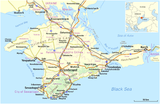
Deutsch: Karte der Krim, 2014
English: Map of the Crimea, 2014 |
|||
| Date | see file history | |||
| Source |
Own work, using
|
|||
| Author | Maximilian Dörrbecker (Chumwa) | |||
| Permission (Reusing this file) |
This file is licensed under the Creative Commons Attribution-Share Alike 2.0 Generic license.
Sie dürfen das Bild zu den folgenden Bedingungen nutzen:
|
|||
| Other versions |
|


File history
Click on a date/time to view the file as it appeared at that time.
| Date/Time | Dimensions | User | Comment | |
|---|---|---|---|---|
| current | 23:20, 21 March 2014 | 2,283 × 1,485 (984 KB) | Chumwa | == {{int:filedesc}} == {{Information |Description = {{de|1=Karte der Krim}} {{en|1=Map of the Crimea}} |Source={{own}}, using * OpenStreetMap data * this file for the orientation map inset |Date = see fil... |
File usage
The following page uses this file: