File:Soufriere Hills Volcano dome collapse.gif

Size of this preview: 600 × 600 pixels. Other resolutions: 240 × 240 pixels | 480 × 480 pixels | 768 × 768 pixels | 1,024 × 1,024 pixels | 1,791 × 1,791 pixels.
Original file (1,791 × 1,791 pixels, file size: 1.27 MB, MIME type: image/gif, looped, 2 frames, 4.0 s)
| This is a file from the Wikimedia Commons. The description on its description page there is shown below.
|
Summary
| Description |
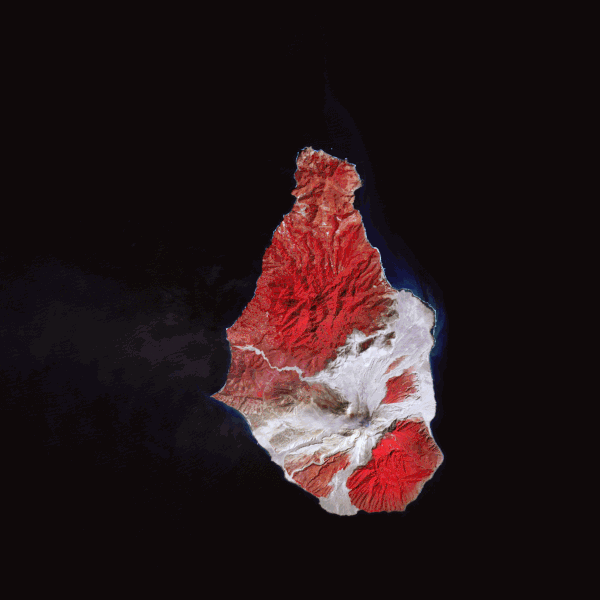
English: These false-colour satellite images show the southern half of Montserrat before and after its dome collapsed. Red areas are vegetated, clouds are white, blue/black areas are ocean water, and grey areas are covered by flow deposits. Fresh deposits tend to be lighter than older deposits. the drainages leading down from Soufrière Hills, including the White River Valley, the Tar River Valley, and the Belham River Valley, were filled with fresh debris. |
| Date | |
| Source | NASA Earth Observatory |
| Author | Robert Simmon |
Images created using data from the NASA/GSFC/METI/ERSDAC/JAROS, and U.S./Japan ASTER Science Team. Instrument: Terra - ASTER.
Licensing
| This file is in the public domain in the United States because it was solely created by NASA. NASA copyright policy states that "NASA material is not protected by copyright unless noted". (See Template:PD-USGov, NASA copyright policy page or JPL Image Use Policy.) | ||
 |
Warnings:
|
| Annotations | This image is annotated: View the annotations at Commons |
File history
Click on a date/time to view the file as it appeared at that time.
| Date/Time | Dimensions | User | Comment | |
|---|---|---|---|---|
| current | 03:46, 26 February 2010 | 1,791 × 1,791 (1.27 MB) | Originalwana | {{Information |Description={{en|1=These false-colour satellite images show the southern half of Montserrat before and after its dome collapsed. Red areas are vegetated, clouds are white, blue/black areas are ocea |
File usage
The following 2 pages use this file: