File:Time Dilation vs Orbital Height.png

Size of this preview: 800 × 534 pixels. Other resolutions: 320 × 214 pixels | 640 × 427 pixels | 1,139 × 760 pixels.
Original file (1,139 × 760 pixels, file size: 53 KB, MIME type: image/png)
| This is a file from the Wikimedia Commons. The description on its description page there is shown below.
|
Summary
| Description |
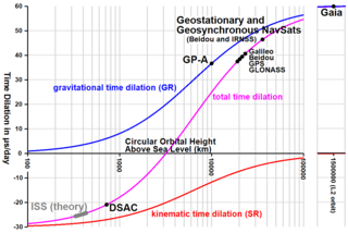
English: Depicts the time dilation as a function of orbital height relative to a stationary observer on Earth. It is common to consider the total dilation as being due to two distinct effects: Kinematic time dilation (customarily referred to as the Special Relativity effect) accounts for slowed time in orbit (relative to the observer on Earth) depending on the orbital velocity associated to a specific orbital height. Gravitational time dilation (customarily referred to as the General Relativity effect) accounts for accelerated time (relative to the observer on Earth) due to the distance to the Earth's gravitational center. Although these sources of time dilation are regularly referred to as "SR time dilation" and "GR time dilation", this usage is incorrect, because general relativity accounts for both effects. The points for the United States GPS, Russian GLONASS, European Galileo, and Chinese Beidou systems have been confirmed by decades of operation of their respective GNSS systems. Geosynchronous and geostationary time dilation has been firmly confirmed by the Chinese Beidou and the Indian Regional Satellite Systems, which use geosynchronous and geostationary satellites to improve accuracy above their respective countries. Also included are the measurement at peak altitude of the 1976 Gravity Probe A experiment, which measured time dilation effects throughout most of its nearly vertical trajectory, and 2021 results from the Deep Space Atomic Clock mission. Time dilation for the ISS (which has orbited at various altitudes, hence the elongated mark) has not yet been confirmed by actual measurement, but this should change with the launching of the Atomic Clock Ensemble in Space (ACES) mission. The Gaia spacecraft does not orbit the Earth, but moves in a Lissajous path around the L2 Lagrange point.
Français : Ces courbes décrivent la dilatation du temps en fonction de la hauteur d'une orbite relativement à un observateur stationnaire sur la Terre. On considère la dilatation totale comme la somme de deux effets distincts : la dilatation liée à la vitesse relative (due à la relativité restreinte) agit sur un ralentissement du temps en orbite (observé depuis la Terre). La dilatation du temps gravitationnelle (due à la relativité générale) accélère le temps en orbite (toujours par rapport à l'observateur sur Terre), car la gravité y est moindre. Bien que ces sources de la dilatation du temps sont référées séparément, cet usage est incorrect, car la relativité générale inclut ces deux effets. Le point pour "GPS" a été confirmé par des décennies de mesures, à la fois par les satellites GPS américains comme par les systèmes russe Glonass et européen Galiléo sur des orbites similaires. La dilatation du temps sur une orbite géosynchrone a été confirmée par les systèmes chinois Beidou et indien IRSS, qui utilisent des satellites géostationnaires sur leurs pays respectifs. Figurent aussi les mesures de l'altitude maximale de l'essai de 1976 "Gravity Probe A", qui a mesuré la dilatation du temps sur une grande partie de sa trajectoire quasiment verticale, et les résultats de la mission "Deep Space Atomic Clock" de 2021. La dilatation du temps de l'ISS (station spatiale internationale, qui a oeuvré sur diverses altitudes, d'où la marque étirée) n'a pas encore été confirmée par une mesure effective, mais ça devrait changer avec le lancement de la mission ACES (Atomic Clock Ensemble in Space). Le satellite Gaia n'a pas une orbite terrestre mais héliocentrique de Lissajous autour du point de Lagrange L2. |
| Date | |
| Source | Own work |
| Author | Prokaryotic Caspase Homolog |
Licensing
I, the copyright holder of this work, hereby publish it under the following license:
This file is licensed under the Creative Commons Attribution-Share Alike 4.0 International license.
- You are free:
- to share – to copy, distribute and transmit the work
- to remix – to adapt the work
- Under the following conditions:
- attribution – You must give appropriate credit, provide a link to the license, and indicate if changes were made. You may do so in any reasonable manner, but not in any way that suggests the licensor endorses you or your use.
- share alike – If you remix, transform, or build upon the material, you must distribute your contributions under the same or compatible license as the original.
File history
Click on a date/time to view the file as it appeared at that time.
| Date/Time | Dimensions | User | Comment | |
|---|---|---|---|---|
| current | 02:00, 24 March 2023 | 1,139 × 760 (53 KB) | Prokaryotic Caspase Homolog | Identified Beidou and IRNSS as systems with geosynchronous and geostationary navigation satellites |
File usage
The following 2 pages use this file: