File:Title Sheet, Index to Drawings - San Francisco Oakland Bay Bridge, Spanning San Francisco Bay, San Francisco, San Francisco County, CA HAER CAL,38-SANFRA,141- (sheet 1 of 20).png

Size of this preview: 800 × 545 pixels. Other resolutions: 320 × 218 pixels | 640 × 436 pixels | 1,024 × 698 pixels | 1,280 × 872 pixels | 14,411 × 9,819 pixels.
Original file (14,411 × 9,819 pixels, file size: 6.08 MB, MIME type: image/png)
| This is a file from the Wikimedia Commons. The description on its description page there is shown below.
|
| This image is a JPEG version of the original TIF image at File: Title Sheet, Index to Drawings - San Francisco Oakland Bay Bridge, Spanning San Francisco Bay, San Francisco, San Francisco County, CA HAER CAL,38-SANFRA,141- (sheet 1 of 20).tif.
However, any edits to the image should be based on the original TIF version in order to prevent generation loss, and both versions should be updated. Do not make edits based on this version. |
Summary
| Warning | The original file is very high-resolution. It might not load properly or could cause your browser to freeze when opened at full size. |
|---|
| Title Sheet, Index to Drawings - San Francisco Oakland Bay Bridge, Spanning San Francisco Bay, San Francisco, San Francisco County, CA | ||||
|---|---|---|---|---|
| Photographer |
Goodman, Zachary, creator |
|||
| Title |
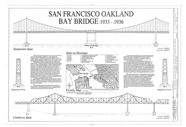
Title Sheet, Index to Drawings - San Francisco Oakland Bay Bridge, Spanning San Francisco Bay, San Francisco, San Francisco County, CA |
|||
| Depicted place | California; San Francisco County; San Francisco | |||
| Date | 1999 | |||
| Dimensions | 24 x 36 in. (D size) | |||
| Current location |
Library of Congress Prints and Photographs Division Washington, D.C. 20540 USA http://hdl.loc.gov/loc.pnp/pp.print |
|||
| Accession number |
HAER CAL,38-SANFRA,141- (sheet 1 of 20) |
|||
| Credit line |
|
|||
| Notes |
|
|||
| References |
Related names:
|
|||
| Source | https://www.loc.gov/pictures/item/ca1352.sheet.00001a | |||
| Permission (Reusing this file) |
|
|||
| Other versions |
.png) .png) .png) .png) .png) _-_San_Francisco_Oakland_Bay_Bridge,_Spanning_San_Francisco_Bay,_San_Francisco,_San_Francisco_County,_CA_HAER_CAL,38-SANFRA,141-_(sheet_14_of_20).png) .png) .png) .png) .png) .png) .png) .png) .png) _-_San_Francisco_Oakland_Bay_Bridge,_Spanning_San_Francisco_Bay,_San_Francisco,_San_Francisco_County,_CA_HAER_CAL,38-SANFRA,141-_(sheet_16_of_20).png) |
|||

.png)
| Object location | | View this and other nearby images on: OpenStreetMap |
|---|
.png¶ms=037.818056_N_-122.346667_E_globe:Earth_class:object_type:object__&language=en)
File history
Click on a date/time to view the file as it appeared at that time.
| Date/Time | Dimensions | User | Comment | |
|---|---|---|---|---|
| current | 19:22, 3 July 2014 | 14,411 × 9,819 (6.08 MB) | Fæ | {{Compressed version|file=File:Title_Sheet,_Index_to_Drawings_-_San_Francisco_Oakland_Bay_Bridge,_Spanning_San_Francisco_Bay,_San_Francisco,_San_Francisco_County,_CA_HAER_CAL,38-SANFRA,141-_(sheet_1_of_20).tif|thumb=nothumb}} =={{int:filedesc}}== {{Ph... |
File usage
The following page uses this file:
.png)