File:World-airport-map-2008.png

Size of this preview: 800 × 400 pixels. Other resolutions: 320 × 160 pixels | 640 × 320 pixels | 1,024 × 513 pixels | 1,280 × 641 pixels | 2,048 × 1,025 pixels.
Original file (2,048 × 1,025 pixels, file size: 1.89 MB, MIME type: image/png)
| This is a file from the Wikimedia Commons. The description on its description page there is shown below.
|
Summary
| Description |
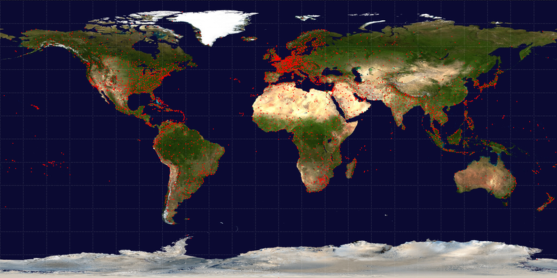
English: Map of airport distribution around the world. Contains 4381 airports, each marked by a red dot. Base map is NASA Blue Marble (PD), airport data is from OpenFlights (Open Database License). |
| Date | |
| Source | Own work |
| Author | Jpatokal, the maintainer of OpenFlights and author of this image |
Licensing
I, the copyright holder of this work, hereby publish it under the following licenses:
This file is licensed under the Creative Commons Attribution-Share Alike 3.0 Unported license.
- You are free:
- to share – to copy, distribute and transmit the work
- to remix – to adapt the work
- Under the following conditions:
- attribution – You must give appropriate credit, provide a link to the license, and indicate if changes were made. You may do so in any reasonable manner, but not in any way that suggests the licensor endorses you or your use.
- share alike – If you remix, transform, or build upon the material, you must distribute your contributions under the same or compatible license as the original.

|
Permission is granted to copy, distribute and/or modify this document under the terms of the GNU Free Documentation License, Version 1.2 or any later version published by the Free Software Foundation; with no Invariant Sections, no Front-Cover Texts, and no Back-Cover Texts. A copy of the license is included in the section entitled GNU Free Documentation License. |
You may select the license of your choice.
File history
Click on a date/time to view the file as it appeared at that time.
| Date/Time | Dimensions | User | Comment | |
|---|---|---|---|---|
| current | 00:06, 4 February 2009 | 2,048 × 1,025 (1.89 MB) | Jpatokal | {{Information |Description={{en|1=Map of airport distribution around the world. Base map is NASA Blue Marble (PD), airport data is from [http://openflights.org/data.html OpenFlights] (GNU Affero). }} |Source=Own work by uploader |Author=[[User:Jpatokal|J |
File usage
The following page uses this file: