North Pole
The North Pole is the point that is farthest north on Earth. It is the point on which axis of Earth turns. It is in the Arctic Ocean and it is cold there because the sun does not shine there for about half a year and never rises very high. The ocean around the pole is always very cold and it is covered by a thick sheet of ice.
There is also a Magnetic North Pole. It is near the physical North Pole. A compass points toward the magnetic North Pole.
There is a star called the North Star (or Polaris) that is always in the sky above the North Pole. People can tell how far north they are by seeing how high the North Star appears in the sky.
Climate
| Climate data for North Pole | |||||||||||||
|---|---|---|---|---|---|---|---|---|---|---|---|---|---|
| Month | Jan | Feb | Mar | Apr | May | Jun | Jul | Aug | Sep | Oct | Nov | Dec | Year |
| Record high °C (°F) | -13 (9) |
-14 (7) |
-11 (12) |
-6 (21) |
3 (37) |
10 (50) |
13 (55) |
12 (54) |
7 (45) |
-2 (28) |
-8 (18) |
-6 (21) |
13 (55) |
| Average high °C (°F) | -29 (-20) |
-31 (-24) |
-30 (-22) |
-22 (-8) |
-9 (16) |
0 (32) |
2 (36) |
1 (34) |
-7 (19) |
-18 (-0) |
-25 (-13) |
-26 (-15) |
-16.2 (2.9) |
| Daily mean °C (°F) | -31 (-24) |
-32 (-26) |
-31 (-24) |
-23 (-9) |
-11 (12) |
-1 (30) |
1 (34) |
0 (32) |
-9 (16) |
-20 (-4) |
-27 (-17) |
-28 (-18) |
-17.7 (0.2) |
| Average low °C (°F) | -33 (-27) |
-35 (-31) |
-34 (-29) |
-26 (-15) |
-12 (10) |
-2 (28) |
0 (32) |
-1 (30) |
-11 (12) |
-22 (-8) |
-30 (-22) |
-31 (-24) |
-19.8 (-3.6) |
| Record low °C (°F) | -47 (-53) |
-50 (-58) |
-50 (-58) |
-41 (-42) |
-24 (-11) |
-12 (10) |
-2 (28) |
-12 (10) |
-31 (-24) |
-41 (-42) |
-41 (-42) |
-47 (-53) |
-50 (-58) |
| % Humidity | 83.5 | 83.0 | 83.0 | 85.0 | 87.5 | 90.0 | 90.0 | 89.5 | 88.0 | 84.5 | 83.0 | 83.0 | 85.83 |
| Source: Weatherbase[1] | |||||||||||||
North Pole Media
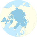
An azimuthal projection showing the Arctic Ocean and the North Pole. The map also shows the 75th parallel north and 60th parallel north.
Temporary research station of German-Swiss expedition on the sea ice at the Geographic North Pole. Drillings at the landing site at 90°N showed an average ice thickness of 2.5 metres (8.2 feet) on April 16, 1990
This pressure ridge at the North Pole is about 1 km (0.62 mi.) long, formed between two ice floes of multi-year ice.
Gerardus Mercator's map of the North Pole from 1595
USS Skate at drift station Alpha, 1958
Soviet icebreaker Arktika, the first surface ship to reach the North Pole, 1977
Related pages
References
- ↑ "CLOSEST DATA FOR NORTH POLE - 440 MI/709 KM, GREENLAND". Weatherbase. Retrieved 23 September 2015.


