Grid plan

A grid plan is the first basic plan in urban planning. It is a type of city plan in which streets run at right angles to each other, forming a grid. In ancient Rome a grid plan method of land measurement was called a centuriation.[1]
Early grid-plans were developed in Indus Valley civilization.[2] It was also widely used in ancient Greece.[3]
Grid Plan Media
A simple grid plan from 1908 of Palaio Faliro.
The city of Adelaide, South Australia was laid out in a grid, surrounded by gardens and parks.
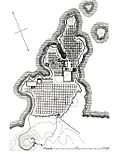
The grid plan of Miletus in the Classical period
Caesaraugusta Roman city matching the current Zaragoza city map:*1.- Decumano; 2.- Cardo; 3.- Foro de Caesaraugusta; 4.- Puerto fluvial; 5.- Termas públicas; 6.- Teatro; 7.- Muralla
Grid blocks in Sapporo circa 1930, subdivisions are named after the numbered roads
The map of St. Petersburg (1717). The grid of 'lines' and 'prospekts' is seen across the whole rectangular Vasilyevsky Island, while actually only the eastern part was built
Related pages
References
- ↑ "Colonia Iulia Flavia Augusta Corinthiensis, AD 70s (Reign of Vespasian)". David Gilman Romano and the Corinth Computer Project. Retrieved 6 April 2015.
- ↑ Senville, Wayne (2010-03-29). "Origins of the Street Grid". PlannersWeb. Retrieved 2024-07-21.
- ↑ Michael Gagarin; Elaine Fantham, The Oxford Encyclopedia of Ancient Greece and Rome, Vol. 5 (Oxford: Oxford University Press, 2010), p. 154
Other websites
- Historical Society of Pennsylvania
- The Great American Grid Archived 2018-08-20 at the Wayback Machine


