Guillaume Le Vasseur de Beauplan
Guillaume Le Vasseur de Beauplan (around 1600-December 6, 1673) was a cartographer, engineer and architect from France. He was in the military in the Polish-Lithuanian Commonwealth army from 1630 until the late 1640's.[1][2] He was forced to move to Ukraine. He was in the military under Stanisław Koniecpolski for one year in 1637. While in the military he helped rebuild the Kodak Fortress. He also built other fortresses in Bar, Ukraine. He also helped build Brody Castle and other buildings in Kremenchuk, Ukraine.[2]
He created the first well described map of Ukraine in 1639.[2] In 1648 he made another map of Ukraine that was very detailed.[1] He moved to Danzig. He made two other very detailed maps and they were engraved by Willem Hondius.[2] He wrote a book called Description d'Ukranie. It was originally named Description des contrés du Royaume de Pologne, when it was first published in 1651. It was published two more times, until 1861. It was the first book to write about Ukraine in great detail. It's still in print today.[2]
Guillaume Le Vasseur De Beauplan Media

General Depiction of the Deserted Plains (in Common Parlance, Ukraine) Together with its Neighboring Provinces, Beauplan (1648). The south is at the top.
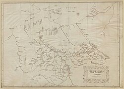
Tabula Geographica Ukrainska created 1639 by Beauplan.

Title page of Description d'Ukranie (1660). Click for full PDF.

References
- ↑ 1.0 1.1 "General Depiction of the Empty Plains (in Common Parlance, Ukraine) Together with its Neighboring Provinces". World Digital Library. Retrieved 20 January 2013.
- ↑ 2.0 2.1 2.2 2.3 2.4 Borschak, Elie. "Beauplan, Guillaume Le Vasseur de". Internet Encyclopedia of Ukraine. Retrieved 20 January 2013.