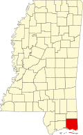
Jackson County, Mississippi
Jackson County is a county in the U.S. state of Mississippi. As of the 2020 census, 143,252 people lived there[1] which makes it the fifth-most populous county in Mississippi. Its county seat is Pascagoula.[2]
| Jackson County, Mississippi | |
| Map | |
 Location in the state of Mississippi | |
 Mississippi's location in the U.S. | |
| Statistics | |
| Founded | 1812 |
|---|---|
| Seat | Pascagoula |
| Largest City | Pascagoula |
| Area - Total - Land - Water |
1,043 sq mi (2,701 km²) 723 sq mi (1,873 km²) 321 sq mi (831 km²), 31 |
| Population - Density |
|
| Time zone | Central: UTC-6/-5 |
| Website: www.co.jackson.ms.us | |
| Named for: Andrew Jackson | |
History
The county was founded in 1812 and named for Andrew Jackson, general in the United States Army and afterward President of the United States.[3]
Geography
According to the U.S. Census Bureau, the county has a total area of 1,043 square miles (2,700 km2), of which 723 square miles (1,870 km2) is land and 321 square miles (830 km2) (31%) is water.[4] It is the largest county in Mississippi by total area.
Bordering counties
- George County - north
- Mobile County, Alabama - east
- Harrison County - west
- Stone County - northwest
Communities
Cities
- Gautier
- Moss Point
- Ocean Springs
- Pascagoula (county seat)
Census-designated places
Unincorporated places
Ghost towns
References
- ↑ "QuickFacts: Jackson County, Mississippi". United States Census Bureau. Retrieved January 4, 2024.
- ↑ "Find a County". National Association of Counties. Archived from the original on May 31, 2011. Retrieved 2011-06-07.
- ↑ Gannett, Henry (1905). The Origin of Certain Place Names in the United States. Govt. Print. Off. p. 167.
- ↑ "2010 Census Gazetteer Files". United States Census Bureau. August 22, 2012. Archived from the original on September 28, 2013. Retrieved November 4, 2014.
Other websites
| Wikimedia Commons has media related to Lua error in Module:Commons_link at line 62: attempt to index field 'wikibase' (a nil value).. |