Jeffersonville, Indiana
Jeffersonville is a city of Clark County in the state of Indiana, United States.
| File:2016WIKI DowntownJeffersonville June13.jpg | |
|
| |
| Location of Jeffersonville in Clark County, Indiana Location of Jeffersonville in Clark County, Indiana | |
| Coordinates: 38°17′44″N 85°43′53″W / 38.29556°N 85.73139°WCoordinates: 38°17′44″N 85°43′53″W / 38.29556°N 85.73139°W | |
| Country | United States |
| State | Indiana |
| County | Clark |
| Established | 1801 |
| Area | |
| • Total | 34.35 sq mi (88.97 km2) |
| • Land | 34.08 sq mi (88.26 km2) |
| • Water | 0.28 sq mi (0.71 km2) |
| Elevation | 446 ft (136 m) |
| Population | |
| • Total | 49,447 |
| • Density | 1,451.04/sq mi (560.26/km2) |
| Census | |
| Time zone | UTC−5 (EST) |
| • Summer (DST) | UTC−4 (EDT) |
| ZIP codes | 47130, 47131, and 47199 |
| FIPS code | 18-38358[3] |
| GNIS feature ID | 0436979[4] |
| Website | cityofjeff.net |
Jeffersonville, Indiana Media

Statue at Warder Park honoring Thomas Jefferson

Spring Street is the main shopping area in downtown.

Frontal view of the Carnegie Library in Warder Park, Jeffersonville

The American Car and Foundry Company in Jeffersonville, Indiana, 1909
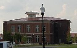
City Hall in the Quadrangle complex

Big Four Station is a park that opened in 2014 at the base of the Big Four Bridge.

Mick's Lounge where Papa John's Pizza began

Part of Jeffboat in Jeffersonville. Jeffboat was the largest inland shipbuilder in the U.S.


References
- ↑ "2020 U.S. Gazetteer Files". United States Census Bureau. Retrieved March 16, 2022.
- ↑ "QuickFacts: Jeffersonville city, Indiana". United States Census Bureau. Retrieved October 24, 2023.
- ↑ "U.S. Census website". United States Census Bureau. Retrieved January 31, 2008.
- ↑ "US Board on Geographic Names". United States Geological Survey. October 25, 2007. Retrieved January 31, 2008.