Kolhapur district
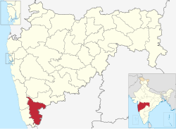
Kolhapur district is a district in the Maharashtra state of India. The city of Kolhapur is its district headquarter. It is situated near Panchaganga river.
 Location in Maharashtra | |
| Country | |
| State | Maharashtra |
| Division | Pune |
| Headquarters | Kolhapur |
| Tehsils | 1. Gadhinglaj, 2. Karveer, 3. Bhudargad, 4. Panhala, 5. Kagal, 6. Shirol, 7. Hatkanangale, 8. Ajara, 9. Chandgad, 10. Gaganbawada, 11. Radhanagari, 12. Shahuwadi |
| Government | |
| • Body | Kolhapur Zilla Parishad |
| • Guardian Minister | Deepak Kesarkar (Cabinet Minister MH) |
| • President Zilla Parishad |
|
| • District Collector |
|
| • CEO Zilla Parishad |
|
| • MPs | |
| Area | |
| • Total | 7,692 km2 (2,970 sq mi) |
| Population (2011) | |
| • Total | 3,874,015[1] |
| • Urban | 32% |
| Demographics | |
| • Literacy | 82%[1] |
| Time zone | UTC+05:30 (IST) |
| Major highways | NH-4, NH-204 |
| Average annual precipitation | 1035 mm |
| Website | kolhapur |
It is bordered by the Sangli district to the North, by Ratnagiri district, Sindhudurg to the West and by Karnataka state to the East.[2]
Kolhapur District Media
References
- ↑ 1.0 1.1 1.2 Swami, V.N. (2020). जिल्हा मध्यवर्ती सहकारी बँक भरती परीक्षा मार्गदर्शक [District Central Cooperative Bank Clerk Grade Examination] (in मराठी). Latur, India: Vidyabharti Publication. pp. 85–86.
- ↑ Patil, Eknath (2021). तात्यांचा ठोकळा [Uncle's Box] (in मराठी). Kolhapur, Maharashtra: Spardha Vishwa Publication. p. 265.
Other Websites
Template:Maharashtra Template:Kolhapur district topics Coordinates: 16°41′52″N 74°13′31″E / 16.697904°N 74.225369°E


