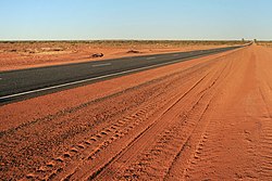
Lasseter Highway

The Lasseter Highway is a highway in the Northern Territory of Australia. It is a sealed road that runs for 244 km (152 mi). It connects Yulara, Kata Tjuṯa and Uluṟu to the Stuart Highway. It is the major access route for tourists heading to Uluṟu-Kata Tjuṯa National Park.[1] The highway is named after the prospector Harold Bell Lasseter, who claimed to have discovered a rich gold deposit (Lasseter's Reef) west of Kata Tjuṯa.
The highway begins in Erldunda, a roadhouse and hotel, on the Stuart Highway (N87). The Stuart Highway connects Darwin in the north and Adelaide in the south and is therefore one of Australia's major highways. From Erldunda, the Lasseter Highway leads west along the southern side of the Basedow and Kernot Ranges. After about 110 km, next to the Kernot Range, there is the junction with the Luritja Highway (S3), which leads north to Kings Canyon. Another 25 km towards the southwest is a rest area that has a view of Mount Conner. A further 22 km away is the Curtin Springs, a cattle station with a roadhouse. A further 100 km west along the highway is the tourist town Yulara. After Yulara, the road meets the Great Central Road, a dirt road that leads into Western Australia through the Petermann Ranges and across the Gibson and Great Victoria Deserts.
There are petrol stations at Erldunda (at the start of the highway), Mount Ebenezer (km 57) and Curtin Springs (km 245).
Lasseter Highway Media
Looking east along the Lasseter Highway toward Erldunda
Driving on the Lasseter Highway near the Uluru-Kata Tjuta National Park in the Northern Territory.
References
- ↑ Steve Parish (2007). Australian Touring Atlas. Archerfield, Queensland: Steve Parish Publishing. p. 100. ISBN 978-1-74193-232-4.


