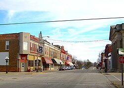
Le Roy, Illinois
Le Roy is a city in Illinois in the United States.
 | |
|
| |
 Location of Le Roy in McLean County, Illinois. | |
 Location of Illinois in the United States | |
| Coordinates: 40°20′22″N 88°45′46″W / 40.33944°N 88.76278°WCoordinates: 40°20′22″N 88°45′46″W / 40.33944°N 88.76278°W[1] | |
| Country | United States |
| State | Illinois |
| County | McLean |
| Township | Empire |
| Government | |
| • Type | Mayor and council, with a full-time city administrator. |
| Area | |
| • Total | 2.42 sq mi (6.27 km2) |
| • Land | 2.40 sq mi (6.23 km2) |
| • Water | 0.02 sq mi (0.05 km2) |
| Elevation | 781 ft (238 m) |
| Population | |
| • Total | 3,512 |
| • Density | 1,460.90/sq mi (564.07/km2) |
| Time zone | UTC-6 (CST) |
| • Summer (DST) | UTC-5 (CDT) |
| ZIP Code(s) | 61752 |
| FIPS code | 17-42971 |
| GNIS ID | 2395656[1] |
| Website | www |
Geography
Le Roy is located at 40°20′50″N 88°45′44″W / 40.34722°N 88.76222°W (40.347168, -88.762293).[4]
According to the 2020 census, Le Roy has a total area of 2.42 square miles (6.27 km2), of which 2.40 square miles (6.22 km2) (or 99.2%) is land and 0.02 square miles (0.05 km2) (or 0.8%) is water.[2]
References
- ↑ 1.0 1.1 1.2 U.S. Geological Survey Geographic Names Information System: Le Roy, Illinois
- ↑ 2.0 2.1 "2020 U.S. Gazetteer Files". United States Census Bureau. Retrieved March 15, 2022.
- ↑ "Le Roy city, Illinois". United States Census Bureau. Retrieved September 20, 2023.
- ↑ "US Gazetteer files: 2010, 2000, and 1990". United States Census Bureau. 2011-02-12. Retrieved 2011-04-23.