Marine Parade
Marine Parade is a planning area and residential estate located in the Central Region of Singapore. Marine Parade is on the tip of the East Coast Park. Marine Parade is at the eastern portion of the Central Reigion.
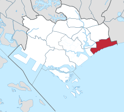
 Location of Marine Parade in the Central Region of Singapore | |
| Coordinates: 1°18′11″N 103°54′28″E / 1.30306°N 103.90778°E | |
| Country | |
| Region | Central Region |
| CDC | |
| Town council |
|
| Constituencies | |
| Government | |
| • Mayor | South East CDC |
| • Members of Parliament | Marine Parade GRC
Mountbatten SMC |
| Area | |
| • Total | 6.12 km2 (2.36 sq mi) |
| Population | |
| • Total | 46,390 |
| • Density | 7,580/km2 (19,632/sq mi) |
| Postal district | 15 |
| Dwelling units | 7,862 |
It boarders five other planning areas. It is the planning areas of Geylang to the north, Kallang to the northwest, Bedok to the northeast, Marina East to the southwest and the Singapore Straits to the south.
History
Before World War Two
Throughout the early to mid 20th century, Marine Parade was a haven for the wealthy community of Singapore. Katong Laska was also founded in Marine Parade around this time.
After World War Two
Since World War Two affected Singapore, after the war, Marine Parade was heavily destroyed. Due to the destruction, a seawall needed repair and the area needed redevelopment. After an argument between the colonial government and the city council, S$318,000 was given to the city council. That money was used to repair the seawall and develop Marine Parade.[4]
After independence
In 1966, the Singaporean government wanted to improve the East Coast in Singapore. It by reclaiming land and building new public housing estates.
In 1966, land reclamation works were started around Marine Parade as part of the larger reclamation project planned for the East Coast.
In the 1970s, the estate was mostly completed. There were new Housing Development Board (HDB) blocks and spaces for the residents.[5]
Marine Parade mainly consists of HDB flats. Today, many private condominiums are also being built in the area.
Infrastructure
Mass Rapid Transit
Marine Parade will be soon served by a few stations on the Mass Rapid Transit network. It will be served on the Thomson-East Coast Line. It will be opened in stage four, which is in 2024.[6]
Community Building
The Marine Parade Community Building is a three story complex. It was completed in 2000. The complex is famous for it's wall mural around the building. It is called "Texturefulness of Life".[7]
The building is home to the Marine Parade Community Club, the Marine Parade Public Library and a performing arts group, The Necessary Stage.[7]
Town Centre
Marine Parade Promenade
Marine Parade is served by a town centre. Named the Marine Parade Promenade, the centre itself consists of several neighbourhood shops, Parkway Centre and a commercial complex. The complex is named Parkway Parade and it houses offices and a shopping mall.[8]
Marine Terrace Haven
Marine Terrace Haven consists of many shops. It houses the Marine Parade Town Council Office and Marine Parade Neighbourhood Police Centre.[9]
Education
Marine Parade has many schools. The bottom shows the schools in Marine Parade.
- Primary Schools
- Secondary Schools
- Junior College
| 40x40px | Wikimedia Commons has media related to Lua error in Module:Commons_link at line 62: attempt to index field 'wikibase' (a nil value).. |
References
- ↑ 1.0 1.1 City Population – statistics, maps and charts | Marine Parade
- ↑ HDB Key Statistics FY 2014/2015 Archived 4 March 2016 at the Wayback Machine
- ↑ "Statistics Singapore - Geographic Distribution - 2018 Latest Data". Retrieved February 11, 2019.
- ↑ "Marine Parade | Infopedia". eresources.nlb.gov.sg. Retrieved 2023-02-11.
- ↑ "The Marine Parade public housing estate". www.roots.gov.sg. Retrieved 2023-02-11.
- ↑ "LTA | Thomson-East Coast Line". www.lta.gov.sg. Retrieved 2023-02-11.
- ↑ 7.0 7.1 "Marine Parade Community Building". Docomomo Singapore. Retrieved 2023-02-11.
- ↑ "HDB | Marine Parade Promenade". www.hdb.gov.sg. Retrieved 2023-02-11.
- ↑ "HDB | Marine Terrace Haven". www.hdb.gov.sg. Retrieved 2023-02-11.