Marton, New Zealand
Marton is a town in the Rangitikei District, New Zealand. It is situated 35 kilometers southeast of Whanganui and 40 northwest of Palmerston North. It has 6 primary schools and two high schools are located in the town.
Town | |
 | |
| Lua error in Module:Infobox_mapframe at line 118: attempt to index field 'wikibase' (a nil value). | |
| Coordinates: 40°04′09″S 175°22′42″E / 40.06917°S 175.37833°ECoordinates: 40°04′09″S 175°22′42″E / 40.06917°S 175.37833°E | |
| Country | New Zealand |
| Region | Manawatū-Whanganui |
| District | Rangitikei District |
| Wards |
|
| Named for | Marton, England |
| Electorates | |
| Government | |
| • Territorial Authority | Rangitikei District Council |
| • Regional council | Horizons Regional Council |
| Area | |
| • Total | 10.99 km2 (4.24 sq mi) |
| Elevation | 152 m (499 ft) |
| Population (June 2022)[2] | |
| • Total | 5,570 |
| • Density | 506.8/km2 (1,312.7/sq mi) |
| Postcode(s) | 4710 |
Marton, New Zealand Media
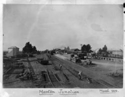
Marton was extended to its new junction station from 1907. The original Pukepapa station is on the far left of the plan, neither being convenient for the original town
- View of the main street in Marton, circa 1924. ATLIB 293732.png
Main Street in Marton circa 1924
- Rangitikei District Council.jpg
Rangitikei District Council offices on 46 High Street, Marton.
References
- ↑ "ArcGIS Web Application". statsnz.maps.arcgis.com. Retrieved 18 March 2024.
- ↑ "Subnational population estimates (RC, SA2), by age and sex, at 30 June 1996-2022 (2022 boundaries)". Statistics New Zealand. Retrieved 25 October 2022. (regional councils); "Subnational population estimates (TA, SA2), by age and sex, at 30 June 1996-2022 (2022 boundaries)". Statistics New Zealand. Retrieved 25 October 2022. (territorial authorities); "Subnational population estimates (urban rural), by age and sex, at 30 June 1996-2022 (2022 boundaries)". Statistics New Zealand. Retrieved 25 October 2022. (urban areas)