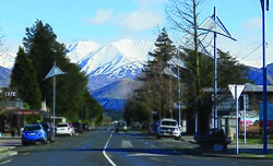
Methven, New Zealand
Methven (Māori: [Piwakawaka] Error: {{Lang}}: text has italic markup (help)) is a small town in Canterbury, New Zealand. It is located on State Highway 77. It is 35 kilometers northwest of Ashburton and 95 kilometers west of Christchurch. It has three schools in the town and is near the skifield of Mount Hutt and has the Staveley ice skating rink nearly.
|
Piwakawaka (Māori) | |
|---|---|
 | |
| Lua error in Module:Infobox_mapframe at line 118: attempt to index field 'wikibase' (a nil value). | |
| Coordinates: 43°38′S 171°39′E / 43.633°S 171.650°ECoordinates: 43°38′S 171°39′E / 43.633°S 171.650°E | |
| Country | New Zealand |
| Region | Canterbury |
| Territorial authority | Ashburton District |
| Community board | Methven Community Board[1] |
| Ward | Western |
| Area | |
| • Total | 4.18 km2 (1.61 sq mi) |
| Elevation | 320 m (1,050 ft) |
| Population (June 2022)[3] | |
| • Total | 1,970 |
| • Density | 471.3/km2 (1,221/sq mi) |
| Postcode | 7730 |
Methven, New Zealand Media
The Methven Walkway alongside the Rangitata Diversion Race, with Mt Hutt in the distance
References
- ↑ "Methven Community Board". www.ashburtondc.govt.nz. Ashburton District Council. Retrieved 11 July 2022.
- ↑ "ArcGIS Web Application". statsnz.maps.arcgis.com. Archived from the original on 14 February 2021. Retrieved 29 October 2021.
- ↑ "Subnational population estimates (RC, SA2), by age and sex, at 30 June 1996-2022 (2022 boundaries)". Statistics New Zealand. Retrieved 25 October 2022. (regional councils); "Subnational population estimates (TA, SA2), by age and sex, at 30 June 1996-2022 (2022 boundaries)". Statistics New Zealand. Retrieved 25 October 2022. (territorial authorities); "Subnational population estimates (urban rural), by age and sex, at 30 June 1996-2022 (2022 boundaries)". Statistics New Zealand. Retrieved 25 October 2022. (urban areas)


