Mount Monadnock
Mount Monadnock, or Grand Monadnock, is a mountain in the New England state of New Hampshire. Authors such as Ralph Waldo Emerson and Henry David Thoreau wrote about the mountain, so it is well-known. It is the highest mountain between the White Mountains of New Hampshire and the Massachusetts Berkshires. It is the highest point in Cheshire County, New Hampshire. Monadnock is one of the most popular mountains to climb in the world.[3]
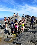
 Rocky plateau on summit of Mount Monadnock | |
| Elevation | 3,165 ft (965 m)[1] |
|---|---|
| Prominence | 2,150 ft (655 m)[2] |
| Listing | #33 New England Fifty Finest |
| Location | |
| Location | Jaffrey / Dublin, Cheshire County, New Hampshire, United States |
| Geology | |
| Type | Littleton formation schist/ quartzite |
| Age of rock | 400 million years |
| Climbing | |
| First ascent | 1725 by Captain Samuel Willard |
| Easiest route | White Arrow Trail 2.3 mi (3.7 km) |
At 3,165 feet (965 m), Mount Monadnock is nearly 1,000 feet (300 m) higher than any mountain within 30 miles (48 km). It is 2,000 feet (600 m) above the nearby land. Mount Monadnock is in the towns of Jaffrey and Dublin, New Hampshire.[4]
The term "monadnock" is used by American geologists to describe any single mountain formed when erosion removes softer rock and leaves harder rock behind. This is called an inselberg in other parts of the world.
Monadnock's bare, isolated, and rocky summit gives people wide, clear views. The mountain is clear mostly because of fires set by early settlers. The first major fire in 1800 cleared trees the lower parts of the mountain to make pasture for animals. More fires and hurricane damaged the forest more. Between 1810 and 1820, local farmers thought that wolves were living in the forest and set the mountain on fire again. The fire burned hot and powerfully for weeks. It destroyed the topsoil and removed trees and plants mountain above 2,000 feet (610 m).[5]
Name
The word "monadnock" comes from the Abenaki language. It means something like "mountain that stands alone."[6]
Trails
- Metacomet-Monadnock Trail Archived 2007-01-12 at the Wayback Machine
- Monadnock-Sunapee Greenway Trail Club
- Maps, Trails and More Information Archived 2011-08-26 at the Wayback Machine
Hiking the mountain
125,000 hikers climb Monadnock each year.[5] The four hour round trip to the top and back on one of the shorter trails may be challenging for the average hiker. Special skills or equipment are not needed from late spring to early fall. Climbing during winter and early spring requires special equipment, clothing, and preparation. Weather on the top of the mountain is often colder and wind is often much stronger than below. Climbers should be careful climbing at any time of year, but it can be especially dangerous from late fall to early spring.
Conservation
Most of the mountain is protected and new buildings or roads are not allowed. The Society for the Protection of New Hampshire Forests owns most of the mountain area. Its Monadnock Reservation is over 4,000 acres (16 km2).[7][8] The state and the town of Jaffrey also own portions of the mountain.[9]
Mount Monadnock Media
The mountain cranberry thrives on Mount Monadnock.
The Billings fold in quartzite and schist of the Devonian Littleton Formation
Abbott Handerson Thayer, Monadnock, Winter Sunrise, 1919, Princeton University Art Museum
References
- ↑ Summit elevation between 960 and 966 m.
- ↑ Key col elevation between 1,000 and 1,020 ft (310 m)
- ↑ "NH Division of Parks & Recreation: Monadnock State Park". Archived from the original on 2012-06-06. Retrieved 2012-08-09.
- ↑ DeLorme Topo USA 6.0. (2006). Mapping software. Yarmouth, Maine:DeLorme.
- ↑ 5.0 5.1 Baldwin, Henry I. (1989). Monadnock Guide 4th edition. Concord, New Hampshire:Society for the Protection of New Hampshire Forests.
- ↑ "Devonian Period." New Hampshire Geology Home Page. Web. 23 Jan. 2011. <http://www.nhgeology.org/devonian.htm>.
- ↑ Society for the Protection of New Hampshire Forests. Retrieved June 22, 2011.
- ↑ New Hampshire Division of Parks and Recreation Archived 2012-07-28 at the Wayback Machine. Retrieved June 22, 2011.
- ↑ GRANIT Data Mapper Archived 2018-01-22 at the Wayback Machine University of New Hampshire. Retrieved February 18, 2008.
Other websites
| Wikimedia Commons has media related to Lua error in Module:Commons_link at line 62: attempt to index field 'wikibase' (a nil value).. |
- NH Division of Parks & Recreation: Monadnock State Park Archived 2012-06-06 at the Wayback Machine
- Mount Monadnock State Park Trail Map Archived 2012-05-27 at the Wayback Machine
- Monadnock Conservancy
- Society for the Protection of New Hampshire Forests
- U.S. Geological Survey Geographic Names Information System: Monadnock Mountain
- U.S. Congress New England National Scenic Trail Designation Act Archived 2016-07-04 at the Wayback Machine
- Antioch University New England's Monadnock Ecological Research and Education Project
- History, photos, trails and points of interest on the mountain. Archived 2012-01-19 at the Wayback Machine


