Negroland

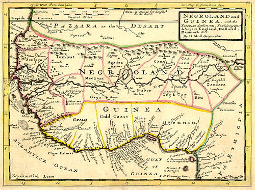
A 1736 map, showing Negroland and Guinea. Present-day Guinea is different
Negroland, or Nigritia was a term Europeans used to describe a region in Africa, south of the Sahara. The region was poorly explored, and Europeans mainly knew the area around the coast. The name was probably a direct translation of the Arabic term "Bilad al-Sudan", which translates to "land of the Blacks".[1]
As can be seen on the map, Europeans of the time believed that the rivers Senegal, Gambia and Niger were in the same river system: one river that divided before flowing into the ocean. [2]
In 1823, approximately the same area was described as "Nigritia" on an American map published by Fielding Lucus Jr.[3] The inhabitants of Nigritia were called Negroes.
References
- ↑ A world apart - Elite black America. 2016-08-04. https://www.economist.com/books-and-arts/2016/08/04/a-world-apart. Retrieved 2019-08-01.
- ↑ "The Negroland of the Arabs Examined and Explained". Google Books. Retrieved 2019-08-01.
- ↑ Lucas Jr, Fielding. "A General Atlas Containing Distinct Maps Of all the Known Countries in the World, Constructed from the Latest Authority. Written and Engraved by Jos. Perkins, Philadelphia. Baltimore". Fielding Lucas Jr. #138, Market Street. Baltimore. Entered ... by F. Lucas Jr. of the State of Maryland June 3, 1823. Retrieved 14 July 2013.