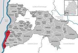
Neuenburg am Rhein
Neuenburg am Rhein is a town in Breisgau-Hochschwarzwald in Baden-Württemberg, Germany.
| Coordinates: 47°48′53″N 7°33′43″E / 47.81472°N 7.56194°ECoordinates: 47°48′53″N 7°33′43″E / 47.81472°N 7.56194°E | |
| Country | Germany |
| State | Baden-Württemberg |
| Admin. region | Freiburg |
| District | Breisgau-Hochschwarzwald |
| Subdivisions | 4 |
| Government | |
| • Mayor (2016–24) | Joachim Schuster[1] (CDU) |
| Area | |
| • Total | 44.12 km2 (17.03 sq mi) |
| Elevation | 230 m (750 ft) |
| Population (2015-12-31)[2] | |
| • Total | 12,081 |
| • Density | 273.82/km2 (709.19/sq mi) |
| Time zone | UTC+01:00 (CET) |
| • Summer (DST) | UTC+02:00 (CEST) |
| Postal codes | 79389–79395 |
| Vehicle registration | FR |
| Website | www.neuenburg.de |
Neuenburg Am Rhein Media
Remnants of the magnificent minster destroyed by the flooding: the choir
References
- ↑ Aktuelle Wahlergebnisse, Staatsanzeiger, accessed 11 September 2021.
- ↑ "Gemeinden in Deutschland nach Fläche, Bevölkerung und Postleitzahl am 30.09.2016". Statistisches Bundesamt (in German). 2016.
{{cite web}}: CS1 maint: unrecognized language (link)
Other websites
- Official website (in German)


