North Smithfield, Rhode Island
North Smithfield is a town in Providence County, Rhode Island, United States.
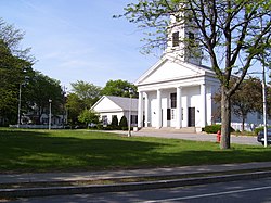
| File:Forestdale school in Rhode Island.jpg | |
| Location in Providence County and the state of Rhode Island. Location in Providence County and the state of Rhode Island. | |
| Coordinates: 41°59′17″N 71°33′7″W / 41.98806°N 71.55194°W | |
| Country | United States |
| State | Rhode Island |
| County | Providence |
| Area | |
| • Total | 24.7 sq mi (64.1 km2) |
| • Land | 24.0 sq mi (62.3 km2) |
| • Water | 0.7 sq mi (1.8 km2) |
| Elevation | 387 ft (118 m) |
| Population | |
| • Total | 12,558 |
| • Density | 522/sq mi (201.6/km2) |
| Time zone | UTC-5 (Eastern (EST)) |
| • Summer (DST) | UTC-4 (EDT) |
| ZIP codes | 02824, 02896 |
| FIPS code | 44-52480[3] |
| GNIS feature ID | 1219815[1] |
| Website | www |
North Smithfield, Rhode Island Media
A rare "stone-ender" known as the John Mowry Jr. or Sayles House on Wesquadomeset (Sayles) Hill near Iron Mine Hill and Sayles Hill Roads in North Smithfield, demolished in the 20th century
Masjid Al Islam mosque on Sayles Hill Road in North Smithfield
The Peleg Arnold Tavern, built around 1690, was home to Peleg Arnold.
Chief Justice Peleg Arnold was a resident of Union Village in North Smithfield.
North Smithfield Middle School, opened in 2008–2009
Mowry House c. 1690, on Providence Pike in North Smithfield
Rustic Drive In Movie Theater (1951) in North Smithfield, the last drive in surviving in the state
References
- ↑ 1.0 1.1 U.S. Geological Survey Geographic Names Information System: North Smithfield, Rhode Island
- ↑ "QuickFacts: North Smithfield town, Providence County, Rhode Island". U.S. Census Bureau. Retrieved August 3, 2023.
- ↑ "U.S. Census website". United States Census Bureau. Retrieved 2008-01-31.


