Northern Cape
The Northern Cape (Afrikaans: [Noord-Kaap] Error: {{Lang}}: text has italic markup (help); Tswana: Kapa Bokone; Xhosa: uMntla-Koloni) is the largest and most populated province of South Africa. It was created on 27 April 1994 when the Cape Province was split up. Its capital is Kimberley.
|
Noord-Kaap (in Afrikaans) Kapa Bokone (in Tswana) uMntla-Kapa (in Xhosa) | |
|---|---|
|
| |
 Location of the Northern Cape in South Africa | |
| Country | South Africa |
| Established | 27 April 1994 |
| Capital | Kimberley |
| Districts | List
|
| Government | |
| • Type | Parliamentary system |
| • Premier | Zamani Saul (ANC) |
| • Legislature | Northern Cape Provincial Legislature |
| Area [1]: Script error: The function "hyphen2dash" does not exist.  | |
| • Total | 372,889 km2 (143,973 sq mi) |
| • Rank | 1st in South Africa |
| Highest elevation | 2,156 m (7,073 ft) |
| Lowest elevation | 0 m (0 ft) |
| Population | |
| • Total | 1,145,861 |
| • Estimate (2019) | 1,263,875 |
| • Rank | 9th in South Africa |
| • Density | 3.072928/km2 (7.958847/sq mi) |
| • Rank | 9th in South Africa |
| Population groups [1]: Script error: The function "hyphen2dash" does not exist.  | |
| • African | 50.4% |
| • Coloured | 40.3% |
| • White | 7.1% |
| • Indian or Asian | 1.7% |
| Languages | |
| • Afrikaans | 53.8% |
| • Tswana | 33.1% |
| • Xhosa | 5.3% |
| • English | 3.4% |
| Time zone | UTC+2 (SAST) |
| ISO 3166 code | ZA-NC |
| HDI (2017) | 0.682[3] medium · 5th |
| Website | www.northern-cape.gov.za |
Northern Cape Media
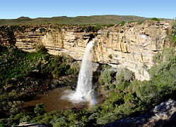
A waterfall situated a few kilometres north of Nieuwoudtville on the road to Loeriesfontein, in the Northern Cape (Namaqualand region).
Sign along R354 welcoming motorists into the Northern Cape from the Western Cape. The sign is in Afrikaans (top left), English (bottom left), Tswana (top right), and Xhosa (bottom right)
Springbok viewed from the old cemetery
Population density in the Northern Cape*Template:Legend-col*
References
- ↑ 1.0 1.1 1.2 1.3 Census 2011: Census in brief (PDF). Pretoria: Statistics South Africa. 2012. ISBN 9780621413885. Archived (PDF) from the original on 13 May 2015.
- ↑ Mid-year population estimates, 2019 (PDF) (Report). Statistics South Africa. 31 July 2019. p. 2. Retrieved 31 December 2019.
- ↑ "Sub-national HDI - Area Database - Global Data Lab". hdi.globaldatalab.org. Retrieved 2018-09-13.


