Ogunquit, Maine
Ogunquit (/oʊˈɡʌŋkwɪt/ oh-GUN-kwit) is a town in York County, Maine, United States. As of the 2020 census its population was 1,577.[2]
 | |
| Coordinates: 43°14′56″N 70°35′57″W / 43.24889°N 70.59917°WCoordinates: 43°14′56″N 70°35′57″W / 43.24889°N 70.59917°W | |
| Country | United States |
| State | Maine |
| County | York |
| Incorporated | 1980 |
| Area | |
| • Total | 15.25 sq mi (39.50 km2) |
| • Land | 4.18 sq mi (10.83 km2) |
| • Water | 11.07 sq mi (28.67 km2) |
| Elevation | 141 ft (43 m) |
| Population | |
| • Total | 1,577 |
| • Density | 377/sq mi (145.6/km2) |
| Time zone | UTC−5 (Eastern (EST)) |
| • Summer (DST) | UTC−4 (EDT) |
| ZIP Code | 03907 |
| FIPS code | 23-54980 |
| GNIS feature ID | 0582646 |
| Website | townofogunquit |
Ogunquit, Maine Media
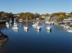
Fishing boat enters Perkins Cove, Ogunquit, Maine.

Surf at Ogunquit, Maine by Edward A. Page (c. 1911)

The beach along the Marginal Way, 2008

The Marginal Way near the Beachmere Hotel, 2008

Lobster Point Lighthouse found along Marginal Way

The bridge at Perkins Cove, 2008
View from the Bridge at Perkins Cove, 2007

The beach at Perkins Cove looking toward the Marginal Way, 2008

Rock formation at Marginal Way

Public Beach in Ogunquit, Maine


References
- ↑ "2020 U.S. Gazetteer Files". United States Census Bureau. Retrieved February 14, 2024.
- ↑ 2.0 2.1 "Profile of General Population and Housing Characteristics: 2020 Demographic Profile Data (DP-1): Ogunquit town, York County, Maine". United States Census Bureau. Retrieved February 14, 2024.