Oiniades
Oiniades (Greek: Οινιάδες) is part of the municipality Missolonghi, Greece. Its area is 270.899 km2.[2] It was named after the ancient town of Oeniadae.
| Oiniades Οινιάδες | |
|---|---|
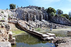
 The ancient shipyard | |
| Location | |
| Time zone: | EET/EEST (UTC+2/3) |
| Elevation (center): | 10 m (33 ft) |
| Government | |
| Country: | Greece |
| Periphery: | West Greece |
| Municipality: | Messolonghi |
| Population statistics (as of 2011[1]) | |
| Codes | |
| Postal: | 300 01 |
| Telephone: | 2210 |
| Auto: | ME |
| File:Flag of Greece.svg | |
History
Ancient Oeniadae (Ancient Greek: Οἰνιάδαι) was a port town on the west bank of the river Achelous. It was one of the most important towns of ancient Acarnania. Oeniadai was first mentioned in the 5th century BC.[3]
It was against a hill in the marshes. These protected it from invaders.[4] It is the same place the modern village, Katochi.
It was an important port on the route to Corfu. It changed its alliances often in the history. At first it was a member of the Peloponnesian League. But, in 424 BC it joined the Delian League. In the Hellenistic period, Oiniadai allied with the Aetolians until 218 BC when Philip V declared it free. From 211-189 BC during the Roman-Macedonian wars the Aetolians controlled it again. In Roman times it became less important.
Municipality
Subdivisions
The communities below are part of Oiniades:
- Neochori Mesolongiou (Neochori, Magoula, Marmara)
- Gouria
- Katochi
- Lesini
- Mastros (Mastros, Platania)
- Pentalofo
Population
| Year | Municipality population |
|---|---|
| 1991 | 10,686 |
| 2001 | 10,227 |
| 2011 | 9,373 |
References
- ↑ Lua error in Module:Citation/CS1/Utilities at line 38: bad argument #1 to 'ipairs' (table expected, got nil).
- ↑ Lua error in Module:Citation/CS1/Utilities at line 38: bad argument #1 to 'ipairs' (table expected, got nil).
- ↑ OINIADAI Greece, entry in The Princeton Encyclopedia of Classical Sites.
- ↑ Template:Cite DGRG
Other websites
- Municipality of Oiniades (in Greek)
- Oiniades (municipality) on GTP Travel Pages
- Ancient Oeniadae on GTP Travel Pages
- Ancient Oeniadae access information Archived 2014-10-19 at the Wayback Machine
- jstor.org, Oeniadae: I. History and Topography by Benjamin Powell, 1904