Okuku, New Zealand
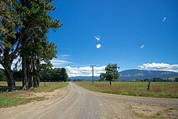
Okuku is a small farming settlement in the Waimakariri District, New Zealand. It is situated 20 kilometers northwest of Rangiora. It contains mix of flat and farmland. It has Okuku River running through the settlement.
 | |
| Lua error in Module:Infobox_mapframe at line 118: attempt to index field 'wikibase' (a nil value). | |
| Coordinates: 43°14′46″S 172°27′07″E / 43.246°S 172.452°ECoordinates: 43°14′46″S 172°27′07″E / 43.246°S 172.452°E | |
| Country | New Zealand |
| Region | Canterbury |
| Territorial authority | Waimakariri District |
| Ward |
|
| Community |
|
| Electorates | |
| Government | |
| • Territorial Authority | Waimakariri District Council |
| • Regional council | Environment Canterbury |
| • Mayor of Waimakariri | Dan Gordon |
| • Kaikoura/Waimakariri MPs | Stuart Smith/Matthew Doocey |
| • Te Tai Tonga MP | Tākuta Ferris |
| Area | |
| • Total | 834.79 km2 (322.31 sq mi) |
| Population (June 2023)[2] | |
| • Total | 810 |
| • Density | 0.970/km2 (2.513/sq mi) |
References
- ↑ "ArcGIS Web Application". statsnz.maps.arcgis.com. Retrieved 9 January 2024.
- ↑ "Population estimate tables - NZ.Stat". Statistics New Zealand. Retrieved 25 October 2023.