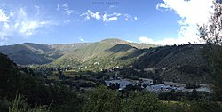
Pir Panjal Range
The Pir Panjal Range (Kashmiri: Pīr Pantsāl) is a group of mountains in the Lesser Himalayan region. They runfrom east-southeast (ESE) to west-northwest (WNW). The range crosses the Indian territories of Himachal Pradesh and Jammu and Kashmir and then Pakistan's Azad Kashmir. The average elevation varies from 1,400 m (4,600 ft) to 4,100 m (13,500 ft).[1] Pir Panjal is the largest range of the Lesser Himalayas. Near the bank of the Sutlej River, it seperates itself from the Himalayas and forms a divide between the Beas and Ravi rivers on one side and the Chenab on the other. The Galyat mountains are a part of this range. The region is connected to the Valley of Kashmir by Mughal Road. It used to be the historical connection of Kashmir with India.
Pir Panjal Range Media
Pir Panjal range as seen from Banihal, Jammu and Kashmir


