Piri Reis map

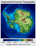
The Piri Reis map is a map of the world drawn on a parchment of gazelle skin by a Turk named Piri Reis (Hadji Muhiddin Piri Ibn Hadji Mehmed) in 1513. This map has been used to support claims for a pre-modern exploration of Antarctica.
Piri Reis Map Media
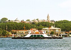
The Topkapı Palace where the map was discovered, viewed from the Bosporus
The Piri Reis map's coastlines (outlined in black) are laid over the 1502 Cantino Planisphere, an earlier portolan world map. They show similarities and increased detail on Piri Reis' South American coast. The peculiar configuration of the Caribbean is usually attributed to the usage of an early map from Columbus, now lost.
Along the map's Western edge, a headless Blemmye (left, holding flowers) converses peacefully with a monkey (right, holding fruit).
Terra Australis, or the Southern Land, is depicted on Petrus Plancius's Orbis Terrarum of 1594 as a massive continent, spanning much of the southern hemisphere. Places discovered but little understood are depicted as the Northern edge of Terra Australis, including Tierra del Fuego south of the Americas and New Guinea.
Sources
- ↑ Harwood, Jeremy 2007 To The End of the Earth. Struik, p69. ISBN 978-1-77007-608-2
+{{{1}}}−{{{2}}}


