Rockville, Connecticut
Rockville is a census-designated place and a village of the town of Vernon in Tolland County, Connecticut, United States. The population was 7,920 at the 2020 census.[2]
 | |
| Etymology: "Going to the Rock" | |
 Location in Tolland County, then Tolland County's location in Connecticut | |
| Coordinates: 41°52′02″N 72°26′54″W / 41.8673°N 72.4483°WCoordinates: 41°52′02″N 72°26′54″W / 41.8673°N 72.4483°W | |
| Country | United States |
| State | Connecticut |
| County | Tolland |
| Region | Capitol Region |
| Town | Vernon |
| Area | |
| • Total | 1.881 sq mi (4.87 km2) |
| • Land | 1.826 sq mi (4.73 km2) |
| • Water | 0.055 sq mi (0.14 km2) |
| Elevation | 367 ft (112 m) |
| Population (2020)[2] | |
| • Total | 7,920 |
| • Density | 4,337/sq mi (1,675/km2) |
| Time zone | UTC-5 (Eastern Time Zone) |
| • Summer (DST) | UTC-4 (Eastern Daylight Time) |
| Postal Code | 06066 |
| FIPS code | 09-65230 |
| GNIS feature ID | 2377857[3] |
Rockville Historic District | |
 | |
George Maxwell Memorial Library, photograph from 2006 | |
| Location: | Roughly bounded by Snipsic St., Davis Ave., West and South Sts., Rockville, Connecticut |
| Coordinates: | 41°51′51″N 72°27′4″W / 41.86417°N 72.45111°W |
| Area: | 550 acres (220 ha) |
| Architect: | Platt, Charles A. et al |
| Architectural style: | Greek Revival, Late Victorian, Classical Revival |
| NRHP Reference#: | 84001173[4] |
| Added to NRHP: | September 13, 1984 |
| Website | rockvillect |
Rockville, Connecticut Media

St. Joseph's Church in downtown.

George Maxwell Memorial Library, postcard mailed in 1911.

Minterburn Mill after becoming an apartment complex.

Hockanum Manufacturing Co., c. 1909.
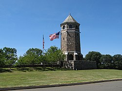
The Tower on Fox Hill, the village's highest peak.

The Hockanum River flowing through a textile mill in Downtown Rockville, Connecticut.


References
- ↑ "2020 Gazetteer (Connecticut)". United States Census Bureau. Retrieved August 7, 2023.
- ↑ 2.0 2.1 "Census - Geography Profile: Rockville CDP, Connecticut". Retrieved August 7, 2023.
- ↑ U.S. Geological Survey Geographic Names Information System: Rockville
- ↑ "National Register Information System". National Register of Historic Places. National Park Service. 2009-03-13.