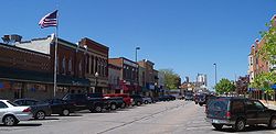
Shakopee, Minnesota
Shakopee (/ˈʃɑːkəpiː/ SHAH-kə-pee) is a city in and the county seat of Scott County, Minnesota. It is located southwest of downtown Minneapolis. The population of Shakopee was 43,698 at the 2020 census.[3]
 | |
 Location of the city of Shakopee within Scott County, Minnesota | |
| Coordinates: 44°46′47″N 93°31′38″W / 44.77972°N 93.52722°WCoordinates: 44°46′47″N 93°31′38″W / 44.77972°N 93.52722°W | |
| Country | United States |
| State | Minnesota |
| County | Scott |
| Incorporated | 1857 |
| Area | |
| • Total | 30.21 sq mi (78.26 km2) |
| • Land | 28.87 sq mi (74.77 km2) |
| • Water | 1.35 sq mi (3.49 km2) 4.47% |
| Elevation | 830 ft (250 m) |
| Population | |
| • Total | 43,698 |
| • Rank | MN: 21st |
| • Density | 1,513.72/sq mi (584.45/km2) |
| Time zone | UTC-6 (Central) |
| • Summer (DST) | UTC-5 (CDT) |
| ZIP code | 55379 |
| FIPS code | 27-59350 |
| GNIS feature ID | 2395854[2] |
| Website | shakopeemn.gov |
Shakopee, Minnesota Media
References
- ↑ "2020 U.S. Gazetteer Files". United States Census Bureau. Retrieved July 24, 2022.
- ↑ 2.0 2.1 U.S. Geological Survey Geographic Names Information System: Shakopee, Minnesota
- ↑ 3.0 3.1 "Profile of General Population and Housing Characteristics: 2020 Demographic Profile Data (DP-1): Shakopee city, Minnesota". United States Census Bureau. Retrieved February 21, 2024.
