Squall line
A squall line, or more accurately a quasi-linear convective system, is a line of thunderstorms. They can form along or ahead a cold front, and can have strong winds with them.[1]
Squall Line Media
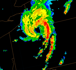
A weather radar image of a mesoscale convective vortex (MCV) over Pennsylvania with a leading squall line
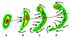
Typical evolution of (a) into a bow echo (b, c) and into a comma echo (d). Dashed line indicates axis of greatest potential for downbursts. Arrows indicate wind flow relative to the storm. Area C is most prone to supporting tornado development.
Shelf cloud on the leading edge of a derecho as photographed in Minnesota
References
- ↑ "Squall Lines". Retrieved 11 August 2024.


