Tassili n'Ajjer
Tassili n'Ajjer is a mountain range in the Algerian part of the Sahara Desert. The name means "Plateau of the Rivers". It 72,000 km2. large. The range is mostly made of sandstone.
| UNESCO World Heritage Site | |
|---|---|
 Landsat multilayer image of Tassili n'Ajjer | |
| Location | Algeria |
| Includes | Tassili National Park, La Vallée d'Iherir Ramsar Wetland |
| Criteria | Cultural and Natural: (i), (iii), (vii), (viii) |
| Reference | 179 |
| Inscription | 1982 (6th Session) |
| Area | 7,200,000 ha (28,000 sq mi) |
| Coordinates | 25°30′N 9°0′E / 25.500°N 9.000°ECoordinates: 25°30′N 9°0′E / 25.500°N 9.000°E |
IUCN Category II (National Park) | |
| Location | Tamanrasset Province, Algeria |
Invalid designation | |
| Official name | La Vallée d'Iherir |
| Designated | 2 February 2001 |
| Reference no. | 1057[1] |
It is known for the prehistoric rock art. The art has herds of cattle, large wild animals including crocodiles, and human activities such as hunting and dancing.
The nearest town is Djanet. It is about 10 km southwest of the range.
Tassili N'Ajjer Media
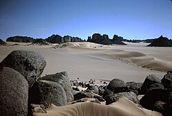
Tassili des Ajjers (grès paléozoïques fluviatiles, env. 450 millions d'années) en cours d'ensablement par les dunes du grand erg oriental, avec des vents dominants venant de l'ouest. Le sable provient de l'érosion de falaises gréseuses ou des granits du Tademaït (?), au sud d'Aïn Salah. Au premier plan: érosion en boule dans un affleurement local de granit. Sahara 1974.
References
- ↑ "La Vallée d'Iherir". Ramsar Sites Information Service. Retrieved 25 April 2018.
![]()


