Ozarks
The Ozarks, also called the Ozark Mountains and Ozark Plateau, are a physiographic, geologic, and cultural highland region of the central United States. It covers much of the southern half of Missouri and a large portion of northwestern and north-central Arkansas. The region also goes westward into northeastern Oklahoma and extreme southeastrn Kansas.
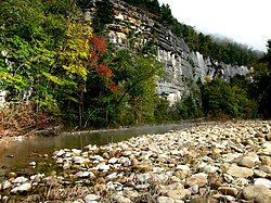
| 280px View of the Ozarks from the Buffalo National River, Newton County, Arkansas | |
| Elevation | 2,561 ft (781 m) |
|---|---|
| Location | |
The name comes from the French Aux Arcs. The name means "with bows" and was given by an early French explorer to the Bow Indians (Quapaw),[1] who were native to the area that later became Arkansas.[1]
Ozarks Media
A rural Ozarks scene. Phelps County, Missouri
The Saint Francois Mountains, viewed here from Knob Lick Mountain, are the exposed geologic core of the Ozarks.
- Roubidoux sandstone bluff.JPG
Outcrop of Roubidoux sandstone along a bluff in Douglas County, Missouri
- Big Spring Missouri 1-02Aug08.jpg
Big Spring, the largest freshwater spring in the Ozarks, discharges 304 million US gallons (1,150,000 m3) of water per day into the Current River.
Canoers on the Current River in the Ozark National Scenic Riverways
Roark Bluff on the Buffalo National River
- Ha Ha Tonka Spring on Lake of the Ozarks.jpg
View of the Ozarks from Ha Ha Tonka State Park on Lake of the Ozarks, Camden County, Missouri
- Shelter on White Rock Mountain.jpg
CCC lookout on White Rock Mountain, Franklin County, Arkansas
References
- ↑ 1.0 1.1 "Ozark-St. Francis National Forest; Forest Information". United States Department of Agriculture, Forest Service. 2014. Retrieved 19 May 2014.

